


Correct the Map: Real cartographic depiction & India's rising role
September 6, 2026
  • Read Ecopy
  • Circulation
  • Advertise
  • Careers
  • About Us
  • Contact Us
Android AppiPhone AppArattai
Organiser
  • ‌
  • Bharat
    • Assam
    • Bihar
    • Chhattisgarh
    • Jharkhand
    • Maharashtra
    • View All States
  • World
    • Asia
    • Europe
    • North America
    • South America
    • Africa
    • Australia
  • Editorial
  • International
  • Opinion
  • RSS @ 100
  • More
    • World Hindu Congress 2026
    • Op Sindoor
    • Analysis
    • Sports
    • Defence
    • Politics
    • Business
    • Economy
    • Culture
    • Special Report
    • Sci & Tech
    • Entertainment
    • G20
    • Azadi Ka Amrit Mahotsav
    • Vocal4Local
    • Web Stories
    • Education
    • Employment
    • Books
    • Interviews
    • Travel
    • Law
    • Health
    • Obituary
  • Subscribe
    • Subscribe Print Edition
    • Subscribe Ecopy
    • Read Ecopy
  • ‌
  • Bharat
    • Assam
    • Bihar
    • Chhattisgarh
    • Jharkhand
    • Maharashtra
    • View All States
  • World
    • Asia
    • Europe
    • North America
    • South America
    • Africa
    • Australia
  • Editorial
  • International
  • Opinion
  • RSS @ 100
  • More
    • World Hindu Congress 2026
    • Op Sindoor
    • Analysis
    • Sports
    • Defence
    • Politics
    • Business
    • Economy
    • Culture
    • Special Report
    • Sci & Tech
    • Entertainment
    • G20
    • Azadi Ka Amrit Mahotsav
    • Vocal4Local
    • Web Stories
    • Education
    • Employment
    • Books
    • Interviews
    • Travel
    • Law
    • Health
    • Obituary
  • Subscribe
    • Subscribe Print Edition
    • Subscribe Ecopy
    • Read Ecopy
Organiser
  • Home
  • Bharat
  • World
  • Operation Sindoor
  • Editorial
  • Analysis
  • Opinion
  • Culture
  • Defence
  • International Edition
  • RSS @ 100
  • Magazine
  • Read Ecopy
Home Bharat

UNGA “Correct the Map” Resolution: Real cartographic representation of the world & India’s rising role

India’s relations with Africa is strategically vital. At a time when the African Union’s initiative has received support from a large part of the world, including India, this vote also appears significant in the broader context of India-Africa relations. India has supported the African demand that does not seek the redrawing of any political boundaries, but rather calls for the world to be viewed in its true geographical proportions

Dr Mayank ChaturvediDr Mayank Chaturvedi
Sep 6, 2026, 08:50 pm IST
inBharat, World, Analysis, International Edition
Follow on Google News
UNGA "Correct the Map" Resolution

UNGA "Correct the Map" Resolution

Facebook
Twitter
WhatsAppTelegramEmail

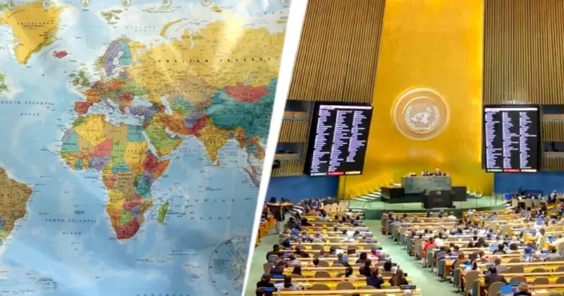
The United Nations General Assembly has now taken an important step towards correcting the old geographical picture of the world map. The ‘Correct the Map’ resolution, introduced by Togo and supported by the African Union, received overwhelming backing from 164 countries. India was also among the countries that voted in favour of the resolution. The United States was the only country to oppose it, while six countries did not participate in the vote. The decision is not legally binding, yet its message carries far and wide: the world should appear on maps as realistically as it exists on the ground.

In fact, the world map that most people across the globe have seen since childhood is based on the 16th-century Mercator projection. Gerardus Mercator developed it for maritime navigation. At that time, the priority was to make it easier to understand directions and routes during sea voyages. Accurate comparisons of land areas were not its purpose.

On Friday, the United Nations General Assembly adopted an African proposal for a new world map, which shows countries’ true size relative to one another.

In favor: 164
Against: 1
Abstentions: 6 pic.twitter.com/5BE4LUiojH

— UN News (@UN_News_Centre) September 4, 2026

As time passed, this projection, created for navigation, became the most widely used means of understanding the world. This is where the problem began. When the Earth’s curved surface is represented on a flat map, landmasses around the poles appear relatively larger, while areas around the Equator appear smaller. A technical convenience gradually became the world’s geographical perception.

The most striking example of this distortion can be seen in a comparison between the sizes of Africa and Greenland. On a traditional Mercator map, the two can often appear to be roughly similar in size, whereas in reality Africa has an area approximately 14 times larger than Greenland. The problem, therefore, is not that the old map was entirely wrong. The problem was that it began to be used for purposes different from those for which it had been created. It was useful for navigation, but it was not suitable for comparing the actual areas of different parts of the Earth. The ‘Correct the Map’ initiative is an attempt to bridge this gap.

The World is Changing, literally
On 4 September 2026, the UN General Assembly overwhelmingly endorsed a non-binding resolution encouraging wider use of the Equal Earth projection instead of Mercator for world maps, to represent continents (especially Africa) in truer relative… pic.twitter.com/jn3KBCewhk

— Sandeep Manudhane (@sandeep_PT) September 5, 2026

Why is this decision important for India too?

An important aspect of this global change is also connected with India. India is a country with a vast landmass located relatively close to the Equator. On equal-area maps, the geographical size of India and other such regions appears in a more realistic proportion than on the traditional Mercator projection. Therefore, this is not merely a story about the size of Africa. It is an initiative to make the visual representation of all those countries whose landmasses have long appeared in distorted proportions on traditional maps more realistic.

Also Read: Dismantling the Global Terror Ecosystem: PM Modi pushes SCO towards coordinated counter-terrorism action

India’s vote in favour of the resolution is significant because, through this initiative to make the geographical representation of the world more factual and balanced, India has joined its voice with that of African countries. India’s role in this vote is also noteworthy because it has consistently advocated a fairer and more balanced global order alongside the countries of the Global South. Standing with Africa on an initiative aimed at presenting its actual size on the world map can be viewed in the context of this broader outlook.

The lines on a map also influence the way we think

It is noteworthy that a map is not merely a collection of lines drawn on paper. A child studying at school sees the world on a map for the first time. That same map forms the foundation of their geographical understanding. It determines how large a continent appears, where a particular country is located and what the geographical balance of the world looks like. This is why the debate over ‘Correct the Map’ is also connected with education and social perceptions. If a vast landmass is continuously shown as smaller than it actually is, while another region is shown as larger than reality, it is natural for this to influence geographical understanding.

By 164 votes to one, Member States endorsed a resolution promoting map projections that more accurately reflect the true size of continents.

Full story: https://t.co/dsL7xpbQa8

— UN News (@UN_News_Centre) September 4, 2026

Important from the perspective of India-Africa relations as well

India’s relations with Africa are not merely diplomatic. The two sides have partnerships in development, trade, education, healthcare, technology and a range of issues connected with the Global South. At a time when the African Union’s initiative has received support from a large part of the world, including India, this vote also appears significant in the broader context of India-Africa relations. India has supported an African demand that does not seek the redrawing of any political boundaries, but rather calls for the world to be viewed in its true geographical proportions.

The United States stands alone in opposition, while the world offers overwhelming support

Another politically interesting aspect of the resolution is that the United States was the only country to oppose it in the vote. Estonia, Georgia, Lithuania, Moldova, Serbia and Ukraine did not take part in the vote. In contrast, 164 countries voted in favour of the resolution. This figure itself indicates that although ‘Correct the Map’ may be an initiative led by African countries, it has the shared support of a large part of the world.

Of course, the United Nations General Assembly resolution is not legally binding, and it does not mean that the map will change overnight in every school, website or official document across the world as soon as it is passed. The actual change will take place gradually. Governments, educational institutions, publishers, media organisations and digital platforms will adopt equal-area maps according to their needs and policies. Even so, the significance of this resolution is far greater than that of any immediate administrative order. The United Nations has acknowledged before the world that the technology used to create maps and the actual geographical picture of the world are not one and the same thing.

Topics: IndiaUNGAAfrican UnionCorrect the MapCartographic RepresentationEqual-Area Map
Share
Tweet
SendShareSend
✮ Subscribe Organiser YouTube Channel. ✮
✮ Join Organiser's WhatsApp channel for Nationalist views beyond the news. ✮
Previous News

Manipur: Security forces defuse 20 kg of IEDs in Jiribam; Two wanted mutants neutralised in Churachandpur

Related News

Representative Image

The 7.8 per cent GDP growth is real; The outrage is manufactured!

NIT Rourkela’s Indigenous EV Battery: Hybrid energy storage architecture & extended life lead lasting mobility

MEA backs UNGA resolution on cartographic representation

MEA backs UNGA resolution on cartographic depiction; Reaffirms India’s non-negotiable sovereignty over J&K and Ladakh

India ramps up aid to flood-hit Nepal

Nepal Floods: Death toll hits 1,344; India airlifts 7th aid tranche, deploys tunnel rescue team for relief efforts

Belgian PM De Wever and Prime Minister Modi

“India Warned, We Ignored”: Belgium PM De Wever flags Europe’s economic dependence; Lauds PM Modi as inspiring leader

Prime Minister Modi & Uzbekistan President Shavkat Mirziyoyev

Uzbekistan envoy hails India’s 7.8% growth amid global upheavals; Calls New Delhi & Tashkent as complementary economies

Load More

Latest News

UNGA "Correct the Map" Resolution

UNGA “Correct the Map” Resolution: Real cartographic representation of the world & India’s rising role

Manipur: Security forces defuse 20 kg of IEDs in Jiribam

Manipur: Security forces defuse 20 kg of IEDs in Jiribam; Two wanted mutants neutralised in Churachandpur

We don’t buy narratives, let people speak for themselves: Dr Sudesh Agrawal

Representative Image

The 7.8 per cent GDP growth is real; The outrage is manufactured!

Bilaspur Police detains 23 people from the Sirgitti area.

Chhattisgarh: Crackdown on Bangladeshi infiltrators: 23 detained in Bilaspur, shifted to detention centre

Religious leaders coming together can be counter to political polarisation: Bawa Jain

Two Bangladeshi prisoners escape police vehicle in Murshidabad

West Bengal: Two Bangladeshi prisoners escape from police vehicle in Murshidabad, one recaptured; Search on for second

Editor of Organiser Prafulla Ketkar and others in a programme in Bhubaneswar

Odisha Literary Festival: Prafulla Ketkar Questions ‘Gen Z’ Label, says Indian youth cannot be defined by algorithms

New Delhi, Sep 06 (ANI): People remove debris during a rescue operation at the site of a building collapse near Satya Niketan in South-West Delhi, in New Delhi on Sunday. (ANI Video Grab)

Building collapse in Delhi: ABVP expresses grief over PG building collapse in Satya Niketan; Rescue operation underway

Arrested accused Manjit Singh Bedi

From US grocery store to FBI wanted list: Who is Manjit Singh Bedi, arrested in Punjab in 600000 dollar fraud case?

Load More
  • Privacy
  • Terms
  • Cookie Policy
  • Refund and Cancellation
  • Delivery and Shipping

© Bharat Prakashan (Delhi) Limited.
Tech-enabled by Ananthapuri Technologies

  • Home
  • Search Organiser
  • Bharat
    • Assam
    • Bihar
    • Chhattisgarh
    • Jharkhand
    • Maharashtra
    • View All States
  • World
    • Asia
    • Africa
    • North America
    • South America
    • Europe
    • Australia
  • Editorial
  • Operation Sindoor
  • Opinion
  • Analysis
  • Defence
  • Culture
  • Sports
  • Business
  • RSS @ 100
  • Entertainment
  • More ..
    • Sci & Tech
    • Vocal4Local
    • Special Report
    • Education
    • Employment
    • Books
    • Interviews
    • Travel
    • Health
    • Politics
    • Law
    • Economy
    • Obituary
  • Subscribe Magazine
  • Read Ecopy
  • Advertise
  • Circulation
  • Careers
  • About Us
  • Contact Us
  • Policies & Terms
    • Privacy Policy
    • Cookie Policy
    • Refund and Cancellation
    • Terms of Use

© Bharat Prakashan (Delhi) Limited.
Tech-enabled by Ananthapuri Technologies