




New Delhi: The United States is witnessing an unusually large mid-decade redistricting exercise, with 10 states changing their congressional boundaries ahead of the 2026 midterm elections. The developments have put the drawing and redrawing of electoral constituencies at the centre of American political debate, as states seek to reshape representation in the House of Representatives.
In the US, the process is generally known as redistricting. Under the normal system, congressional districts are redrawn once every 10 years following the decennial census. The current cycle, however, has departed sharply from that pattern. According to the National Conference of State Legislatures, 10 states have changed their congressional maps since the summer of 2025: Alabama, California, Florida, Louisiana, Missouri, North Carolina, Ohio, Tennessee, Texas and Utah.
The US Census Bureau has separately confirmed that congressional district plans for the 120th Congress were submitted by these 10 states. Its records include the new district plans for Alabama, California, Florida, Louisiana, Missouri, North Carolina, Ohio, Tennessee, Texas and Utah.
The redistricting drive has significant political consequences. A Reuters analysis found that Republicans improved their prospects in 16 congressional districts through the new maps, while Democrats gained an advantage in six newly redrawn districts. The overall changes therefore provide Republicans with a larger electoral advantage, although the Democratic Party continues to compete for control of the House in the November 2026 midterm elections.
California joins the redistricting battle, giving Democrats an electoral advantage
The changes are not confined to Republican-controlled states. California also redrew its congressional map, producing a Democratic advantage. This illustrates that the redistricting battle has developed into a wider political contest in which both parties are seeking to shape electoral boundaries in states where they have the political ability to do so.
Texas, Florida, North Carolina, Ohio, Tennessee, Alabama and other Republican-led states have pursued maps designed to strengthen the party’s position in Congress. At the same time, California’s redrawing demonstrates that Democrats have also used the redistricting process to pursue greater representation. The result is a national contest over how congressional constituencies should be configured before voters go to the polls in the 2026 midterm elections.
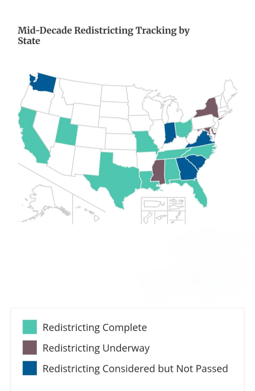
The process has also generated major legal battles. Missouri has become one of the clearest examples. The Republican-backed state legislature approved a new congressional map that could help the party gain an additional House seat. The Missouri Supreme Court, however, ruled on September 3 that the new boundaries could not be used unless voters approved them in a referendum.
The Missouri dispute has since become even more complicated. On September 8, the US Supreme Court declined to reinstate the Republican-drawn map, while a federal district judge separately issued an order requiring Missouri to use the new boundaries for the November 2026 midterm elections. The conflicting decisions have created uncertainty over which congressional map will ultimately govern the state’s election.
Despite the disputes, the broader picture is clear that electoral boundaries in the United States are being actively redrawn outside the traditional census timetable. The 10-state exercise demonstrates that congressional representation can become the subject of substantial political and legal debate when states seek to alter the composition of their electoral districts.
As Americans prepare for the November 2026 midterm elections, the new maps will directly influence the districts in which candidates compete and the constituencies they seek to represent. The unusually broad redistricting exercise has consequently made the drawing of electoral boundaries one of the defining institutional battles of the 2026 US midterm election cycle.