




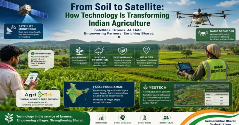
There is an ancient understanding embedded in Indian civilisation: the farmer who tends the earth sustains the nation. Annadaata the provider of food has always occupied a place of reverence in India’s cultural imagination. What is new and what marks a decisive shift in how India honours that reverence, is the scale and sophistication of the technological architecture now being deployed in service of the Indian farmer. From the satellites orbiting the earth to the drones buzzing over paddy fields in Bihar and the AI chatbots responding to crop queries in fourteen languages, India agricultural transformation is no longer a promise it is a programme in full motion.
The Government of India has woven together an interconnected suite of modern technologies satellites, drones, Artificial Intelligence, Remote Sensing, Geographic Information Systems, and the Internet of Things to build what may be described as the world most ambitious publicly funded agri-tech ecosystem. The beneficiary is not the well-resourced commercial farmer but the smallholder, the tribal cultivator, the woman in a self-help group in Telangana, the marginal farmer in Vidarbha seeking crop insurance relief. Technology, in this framework is not an elite instrument it is an instrument of Antyodaya.
Reading the Earth from Space; Remote Sensing and GIS
India’s agricultural intelligence begins above the clouds. The FASAL programme Forecasting Agricultural Output using Space, Agro-meteorology and Land-based observations uses multispectral satellite imagery and Synthetic Aperture Radar data to generate pre-harvest production forecasts at the national, state, and district level. It currently monitors eleven major crops, including paddy, wheat, cotton, sugarcane, mustard, and gram, across twenty states. In a country where food security is both an economic and a political imperative, the ability to anticipate production shortfalls weeks before harvest gives policymakers a decisive advantage.
Disaster does not wait for administrative convenience, and neither does MNCFC the Mahalanobis National Crop Forecast Centre. Through a continuous stream of satellite-derived inputs, MNCFC generates vegetation condition maps, soil moisture assessments, drought condition analyses and flood inundation data. When hailstorms batter crops in Maharashtra or excess rains drown fields in Assam, this remote-sensing intelligence activates the response chain connecting field reality to government action in near real time.
The Krishi Decision Support System (Krishi-DSS) brings this data together into a single integrated platform, standardising geospatial and non-geospatial information satellite imagery, weather data, soil profiles, crop signatures, reservoir levels and groundwater status alongside government scheme databases. The system does not merely aggregate data; it enables evidence-based governance. Crop sown patterns can be mapped, diversification strategies modelled and technology-driven yield assessments generated for the settlement of crop insurance claims under the Pradhan Mantri Fasal Bima Yojana cutting the time between disaster and relief. BharatVistaar has served over 5.9 lakh farmers and resolved more than 93 lakh queries with proof that AI-powered agricultural advisory is no longer a pilot project but a public service at scale.
YESTECH and WINDS: Precision at the Panchayat
Two initiatives deserve particular attention for the granularity they bring to agricultural governance. YESTECH: the Yield Estimation System based on Technology operates under the PMFBY insurance framework and uses satellite-based crop yield models to estimate production at the Gram Panchayat level. For paddy, wheat and soybean farmers across twelve states, this means that insurance claims can be assessed and settled not on the basis of broad district-level assumptions but on hyper-local satellite data. The difference between a district estimate and a Gram Panchayat estimate is the difference between approximate justice and precise justice.
Complementing yield estimation is WINDS the Weather Information Network and Data Systems initiative which is expanding India’s weather data infrastructure down to the block and village level. Automatic Weather Stations at the Block and Tehsil level and Automatic Rain Gauges at the Gram Panchayat level, are creating a granular, real-time weather network that feeds directly into crop advisory systems, insurance frameworks and disaster response mechanisms. Currently active in seven states, WINDS is the backbone on which precision agro-meteorology will rest.
Drones in the Field: Kisan Drones and Namo Drone Didis
If the satellite watches from above, the drone works at arm reach. The Government push to mainstream drone technology in Indian agriculture has unfolded on two fronts one focused on mechanisation, the other on women’s empowerment. Under the Sub-Mission on Agriculture Mechanisation (SMAM), financial assistance of up to fifty percent has been extended for the procurement of Kisan Drones by agriculture graduates and small and marginal farmers in the North-Eastern states, with forty percent assistance for other farmer categories. Custom Hiring Centres for Kisan Drones receive the same forty percent financial support ensuring that even farmers who cannot own a drone can access one. A total of 2,122 drones has been distributed or approved under the SMAM scheme.
The Namo Drone Didi scheme adds a dimension that goes beyond agricultural efficiency to social transformation. Selected Women Self Help Groups have been equipped with drones to provide rental services to farmers primarily for spraying fertilisers and pesticides. 1,094 drones have been distributed to Drone Didis across India, with all SHG members receiving certified training from Remote Pilot Organisations authorised by the Directorate General of Civil Aviation. A woman in rural Madhya Pradesh, trained and certified, operating a drone to service her village’s farms this is Nari Shakti expressed in its most tangible, productive form.
Artificial Intelligence: From Pest to Platform
Artificial Intelligence has entered Indian agriculture not as a futuristic abstraction but as a practical, operational tool addressing farmers’ most immediate problems. The National Pest Surveillance System (NPSS) exemplifies this approach. Using AI and machine learning, the system enables farmers to photograph pest-infested crops and receive instant identification and advisory guidance. It currently covers 73 crops and 436 pests a breadth of coverage that no human extension network could replicate at comparable speed or cost. As of the latest data, 35,565 advisories have been issued through the application, each representing a timely intervention that may have spared a family harvest.
BharatVistaar the Virtually Integrated System to Access Agricultural Resources operates at a larger scale and ambition. This multilingual AI-powered Digital Public Infrastructure provides farmers with real-time, location-specific advisories through a chatbot available on web, mobile, and a dedicated telephone line. It covers eighteen Central Government schemes, crop and livestock advisories, weather forecasts, mandi prices, pest and disease identification, soil health recommendations, and grievance redressal all in the farmer own language. The platform has already served more than 5.9 lakh farmers and addressed over 93 lakh queries, making it one of the most used agricultural AI platforms in the world.
Sunita Devi, 38 grows paddy and vegetables on three acres in Gaya district, Bihar. Her husband migrated to Patna for work during the lean season, leaving her to manage the farm and a household of five. Last kharif, when her paddy crop showed yellowing leaves and unusual wilting, she had no one nearby to consult the nearest Krishi Vigyan Kendra was twelve kilometres away.
“Maine phone pe photo bheja. Minute bhar mein jawab aaya: kaun sa keeda hai, kaunsi dawa daalni hai. Fasal bach gayi.” (I sent a photo on the phone. Within a minute came the reply, which pest it was, which spray to use. The crop was saved.)
Sunita used BharatVistaar chatbot through a feature phone helpline. The advisory delivered in Hindi, within seconds identified a nitrogen deficiency compounded by a bacterial leaf blight, and recommended a targeted urea application alongside a specific fungicide.
KISAN SARATHI, developed by ICAR and deployed through Krishi Vigyan Kendras, completes the AI advisory triangle. With more than 2.97 crore farmers registered on the platform, it delivers crop-specific guidance through a network of knowledge centres that bridge the gap between scientific research and field practice carrying the agronomist’s expertise into the remotest holding.
AgriStack and the Digital Farmer Identity
Undergirding all these programmes is the AgriStack project under the Digital Agriculture Mission a foundational data infrastructure that assigns each farmer a unique digital identity, integrating land records, crop data, input history and scheme eligibility into a single accessible profile. This Farmer ID is not a bureaucratic exercise in data collection, it is the architecture of targeted and efficient service delivery.
The practical outcomes are already visible. Direct Benefit Transfers under PM-KISAN have become more accurate. Fertiliser bookings are streamlined. Kisan Credit Card loans are now being sanctioned within half an hour in pilot districts. Disaster relief disbursements in Maharashtra have been accelerated. Procurement under the Price Support Scheme of PM-ASHA and enrolment under PMFBY are both being linked to Farmer IDs, eliminating duplication and exclusion. Digital Crop Survey data, is generating near real-time crop production estimates that feed directly into policy turning ground-level agricultural reality into actionable national intelligence.
The Krishi MApper application, under the National Mission on Natural Farming extends this digital fabric to geo-reference natural farming clusters, supporting India’s growing commitment to chemical-free and climate-resilient agriculture.
Bharatiya Agriculture: Rooted, Reimagined
What unifies these programmes are FASAL and YESTECH, Namo Drone Didi and NPSS, BharatVistaar and AgriStack, which is a coherent vision of agriculture as a domain where ancient knowledge and modern capability can coexist and reinforce each other. Indian farmer does not need to choose between the wisdom of the soil and the intelligence of the satellite, the government technological architecture is designed to serve both.
The transformation underway in Indian agriculture is civilisational. A nation that feeds itself feeds its sovereignty. And a nation that arms its farmers with satellites, AI and drones does not merely produce food, it produces the future.