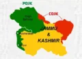
A map published by the Office of the United States Trade Representative (USTR) in connection with the newly announced India-US interim trade framework has triggered diplomatic and strategic discussion after it depicted the entire Jammu and Kashmir region, including Pakistan-occupied Jammu and Kashmir (PoJK) and China-occupied Aksai Chin as part of India.
The map was shared on social media platform X on February 7 as New Delhi and Washington unveiled the contours of an interim trade agreement aimed at resetting bilateral economic ties. While India has consistently maintained that Jammu and Kashmir is an integral part of the country, the US depiction marks a visible shift from earlier American maps, which typically portrayed PoJK as a disputed territory using dotted lines or accompanying disclaimers.
Historically, the United States has sought to maintain formal neutrality on territorial disputes between India and Pakistan, particularly over Jammu and Kashmir. Official US maps and documents have often reflected this stance by avoiding firm boundary demarcations in the region. The absence of any such qualifiers in the USTR map has therefore attracted attention.
The development stands in contrast to earlier positions taken by Washington. In 2011, for instance, a map on the US Department of State website depicted Pakistan-occupied Kashmir as part of Pakistan, while merely noting India’s claim over Aksai Chin. At the time, New Delhi formally objected to the depiction, with the Ministry of External Affairs (MEA) stating in 2012 that India had “consistently rejected incorrect depiction of its borders” and had raised the issue with US authorities on multiple occasions.
The timing of the map’s release is also significant. India and the United States are currently working to recalibrate relations after a period of strain, particularly during US President Donald Trump’s earlier term, when tariffs on Indian goods were raised sharply to 50 per cent. Under the newly announced interim trade framework, those tariffs have reportedly been reduced to 18 per cent, the lowest applied to any Asian country signalling a thaw in economic relations.
Many have described the map as a symbolic setback for Pakistan’s recent diplomatic outreach in Washington. Over the past six months, Pakistan’s Army chief General Asim Munir has visited the US three times and reportedly held two meetings with President Trump, in what Islamabad viewed as a renewed engagement with American policymakers.
While US officials have not issued any public clarification or comment on the map, and there is no formal indication of a declared policy shift, the visual messaging has been widely interpreted as a quiet but deliberate signal. By placing India’s full territorial claims on an official trade-related document, Washington appears to have conveyed a nuanced geopolitical message alongside a major economic announcement.
For India, the depiction aligns with its long-standing position on sovereignty and territorial integrity.