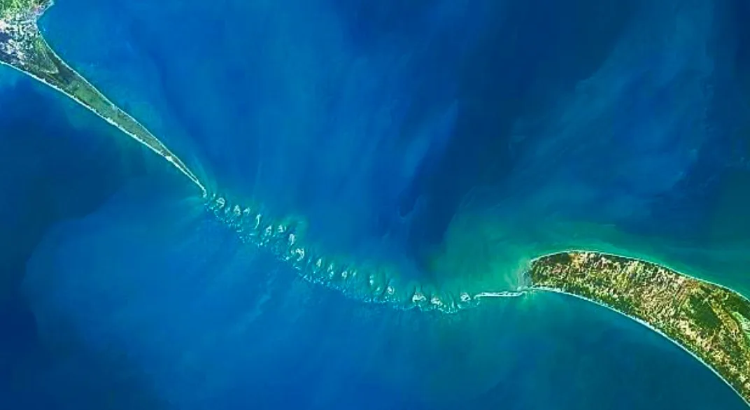
The Indian Space Research Organisation (ISRO) with the help of NASA (National Aeronautics Space Administration) ICE-Sat-2 Satellite has released a detailed map of the Ram Setu or Adam’s Bridge. According to the Optical Satellite imagery verification, the pathway is 99.8 percent submerged in water. The bridge is 29 meters long and extends eight meters over seabed. The released map is of 10-meter resolution map created after six years of data collected.
According to reports, it is said that the bridge is 1.5km wider. This bridge is located between Mannar islands off the northwest coast of Sri Lanka and Rameshwaram island, India. Scientists from ISRO ‘s Jodhpur and Hyderabad National Remote Sensing Centre revelled this map, which depicts a comprehensive image of the bridge underwater and was created using advanced laser technology from a US satellite ICE Sat-2’s Green Laser allowed for deeper penetration detecting the seafloor up to 40 meters deep.
Earlier, satellite-based observations had revealed the undersea structure but were largely focused on exposed sections of the bridge. The sea in the area is super shallow only one meter deep to ten meter deep in places that hindered navigation and any attempts to map the ridge with ships.
Researchers acquired around 0.2 million photons from the ICE-Sat-2 which provided depth information critical for creating high resolution bathymetric data. A team by Giribabu Dandabathula uncovered tiny 11 channels with a depth of 2-3 meters and utilised 3-D derived metrics to estimate the bridge’s physiology. The scientists believe that these narrow channels play a key role in protecting and preserving the structure from the ferocity of wave action.
Until the 9th century AD Persians called this bridge as “Sethu Bandhai” and its was situated above sea level until 1480 when a powerful storm ravaged the area, causing significant damage that resulted in the bridge becoming submerged underwater. Ram Setu has great historical significance to the people of India as it is connected with Indian culture and is said to have been built by Bhagwan Ram’s Army to Lanka (Sri Lanka) to get Devi Sita back who was kidnapped by a ten headed demon called Ravana. An official from the British East India Company coined the word Adam’s Bridge for the Ram Setu.
Both India and Sri Lanka were once part of an ancient supercontinent called Gondwanaland that separated and drifted northward as an isolated giant island landmass in the Tethys Sea until it crashed into the supercontinent called Laurasia sometime between 35 million and 55 million years ago. Over millions of years, sea levels have risen and fallen, submerging and exposing the ridge, said Vahia who has independently been studying the history of astronomy and science in ancient civilizations.