
India is ready to step for one more defining moment in its space odyssey, unfolding on July 30, 2025, at precisely 5:40 PM IST. ISRO’s GSLV‑F16 will take flight from the Satish Dhawan Space Centre, Sriharikota, bearing the groundbreaking NASA‑ISRO Synthetic Aperture Radar (NISAR) satellite. A proud moment for rising India with global partners like NASA, thus elevating Earth observation to new heights.
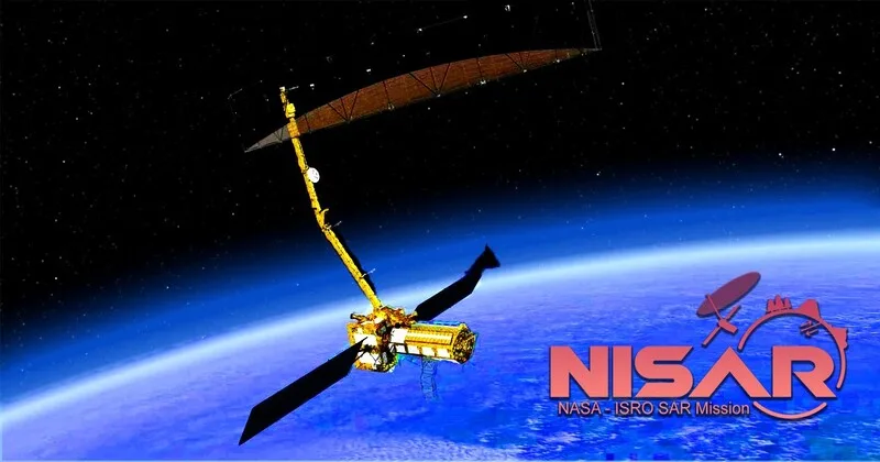
The NISAR mission is a confirmation of more than a decade of collaboration between two leading space agencies. Engineers at URSC in India and JPL at NASA collaborated to design a satellite that combines India’s S band SAR with NASA’s L band SAR to produce the world’s first dual frequency radar imaging satellite. This elaborate partnership, built on technical trust and shared ambition which truly embodies the Prime Minister Modi’s vision of India as a “Vishwa Bandhu” a global friend and contributor to humanity’s scientific progress.
NISAR Weighs 2,392 kg, this collaboration valued at nearly US $1.5 billion, with India contributing around Rs 788 crore (roughly $95–96 million) smartly investing for immense returns in climate resilience and technology leadership. On the pre-launch day, the satellite was integrated safely and GSLV F16 rolled out to the pad on July 24. On July 29 at 2:10 PM IST, ISRO initiated a 27.5 hour countdown, with both agency teams locking down every command and system check, leading to this historic night. The preparation in Sriharikota under good skies resonated with India’s shared desire for excellence and exploration.
Once airborne, about 19 minutes later, NISAR will be placed into a sun synchronous polar orbit at a height of about 743 km, orbiting the Earth every ≈97 minutes and covering a 242 km wide providing almost full global coverage every 12 days, both day or night in every season. The actual work of the mission starts after liftoff. The satellite will go into its deployment and commissioning phases for the next 90 days a very careful process of deploying its gigantic 12 meter unfurl able antenna, calibrating both the radar instruments, and checking all onboard equipment. ISRO and JPL engineers will work together to ensure that NISAR is absolutely ready for scientific operations.
After this in-orbit checkout (IOC) phase with practical hands-on, after 70 to 90 days, NISAR will transition to its science operations phase, which will last three years and can be extended to five years. NISAR starts sending high-resolution Earth observation data and images freely available within a day or two of collection and real-time data during disaster situations.
The satellite’s unparalleled ability to observe surface change to millimetric levels, even under clouds and darkness, makes it an essential tool for disaster management, earthquakes and landslides to glacier flow and flood prediction. It delivers equally valuable information on agriculture, soil moisture, forest biomass, coastal erosion and infrastructure stability all power and guidance for policymakers and scientists.
With open access to data, NISAR is a national asset and international public good. Its publicly available data opens up Earth science to democratize it, facilitating research and development in developing nations that otherwise might not have these abilities. Union Minister Dr Jitendra Singh rightly described NISAR as “India’s scientific handshake with the world” and stated the mission is a testament to what democracies dedicated to science and world welfare can achieve collectively.
Today’s launch is a milestone moment for ISRO with the first time the GSLV rocket being utilized to place payloads in sun-synchronous orbit, marking India’s rising technical ability in satellite delivery systems. The achievement is a testament to countless generations of scientists, engineers and visionaries who brought India’s space program from modest beginnings to world leadership.
As the country stands united, hearts full of patriotism, this mission means more than technology it marks India’s determination to serve humanity using knowledge and innovation. In the years to come, NISAR will assist communities in preparing for calamities, monitor the melting of glaciers, protect biodiversity and plan sustainable urban development. Its effects will be registered from the Himalayas to the Indo-Gangetic plains and across continents.
In colleges, research laboratories, government departments, and disaster centers, the impact of NISAR will be far-reaching. Climate models will be improved by scientists, agronomists will track water and crop usage, environmentalists will monitor forest cover loss and city planners will track subsidence in infrastructure. What India is launching tonight is not a satellite, but a beacon of ensuring resilience and custodianship of our planet’s future.
As the rocket’s blaze dissolves in the evening sky and the satellite departs into orbit, India’s flag glows bright in space. Today, we do not only see a historic launch, but the beginning of an era when Indian science touches the world’s conscience, enabling humankind to watch and tend the better future for citizens.


Comments