MapMyIndia is a deep tech company, which with its state-of-the-art mapping, navigation, geospatial analytics and IOT, is one of India’s leading companies working towards an Aatmanirbhar Bharat. Organiser representative Deepti J Verma talked to Rohan Verma, CEO of MapMyIndia, about what it takes to navigate the start-up ecosystem and its breakthrough from 15 years of Digital Colonisation. Excerpts:
Tell us how your parents started the company and when did you decide to join it ?
MapMyIndia was started in 1995 by my parents. They are IIT Roorkee and BITS Pilani graduates. They believed that someday 80 per cent of all Indian data will have a location component to it, and digital maps will play an important role in our lives – whether individuals, businesses, Government or society. At that time, there were no digital maps available in India. Now people call them visionaries but at that time they were defamed, made fun of and called ‘crazy’. In that interregnum, they went walking, running and driving through millions of miles across the country, collecting and assembling data and saving it digitally. Since then, it’s been their conviction, and mine too, that there are infinite utilities and cases of maps – whether it’s food delivery, e-commerce, Government infrastructure planning or just our daily routine affairs or personal lives.
From coming close to selling the company at one point to getting it listed in 2021 and then having been accredited and declared as an Indian Unicorn, it has been quite a leap forward. What happened in your favour in this interregnum?
We realised along the way that we had built a digital platform and an institution. It was obviously natural for other big players to be interested in its strategic or management buying, and on our part, a temptation to sell emerged, but as the realisation set in that we have built something concrete and sound foundation to last, a floatation of an IPO was the most logical step. As you might observe, MapMyIndia is a unique entity in its concept. There’s no company matching its features and characteristics in the world, leave alone India, as it is a company that has covered a country as vast and complex as India. It has created a digital asset of such a colossal volume. It has also created a robust technological platform besides asset base to deliver other services for consumers and enterprises.
“The PM has already christened this decade as India’s ‘techade’, and it’s exciting to see how we can work together to help and enable Indians – like using geospatial technology for infrastructure development, deciding where roads, schools, and hospitals should come up”
MapMyIndia has spoken against “digital slavery of 15 years” caused by the Google ecosystem, with Google Maps being a pre-loaded option on phones. Let us talk about that. What have been some of the biggest challenges and wins for a homegrown deep tech company in the last couple of years?
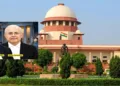
In 1700s, India’s GDP was 27 per cent of the world market. After the British and the East India Company left India after 200 years of ruling, looting and plundering, it was down to only 3 per cent. Everything that India had to offer in terms of resources and market was abused and misused for the gain of the British. However, at that time very few people could have realised what was happening. In fact, many among the Indian public still favour that imperialistic mindset and believe the British administered us well, imparted great education and provided us infrastructure. This is a deep-rooted colonisation attitude. Similarly, in the last 15 years, very few people have realised and questioned why, with all our technical talent and entrepreneurial expertise, India remains a market for global digital and tech giants and India has not become a market leader. Indians, without questioning, are using all foreign big tech products. The reason for that is, as very rightly investigated by the Competition Commission of India, and upheld by the Supreme Court, that Google has digitally colonised India in such a manner that people don’t know about indigenous apps. All we are asking for is to extend to us a level playing field and then Indian consumers will benefit from it.
That brings us to the question of how consumers benefit from this app. How uniquely Indian is it? You have spoken of the product market fit; what makes it perfect for the Indian consumers?
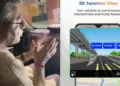
It has about 20 features, which are unique and dedicated to the Indian consumers. For example, Google Maps only show you a 2D view of the roads, which becomes absurd and confusing, especially when there’s a flyover. The MapMyIndia app, on the other hand, displays a 3D view so that you can have an added and informed decision. The 2D view was one reason attributed to car crashes and accidents. This also resulted in the fatal car accident of Cyrus Mistry. The MapMyIndia app could’ve averted that. We also tell consumers about curves, potholes, or speeding cameras, which help prevent rash driving and accidents. Our expertise doesn’t end here. We are now guiding virtual tours of religious places and other cultural heritage spots. Our 3D views not only give a real-time feel of the place, for a tourist or targeted consumer but can also help the authorities during disaster management, emergency response or counter-terrorism.
Let’s talk about your collaboration with the Government. How is the current government helping in leveraging a homegrown company? And how is an indigenous deep tech company, in turn, helping the Government and public service initiatives? Take us through your collaboration with the CoWIN app as well as ISRO?
When COVID-19 struck, our first response was how to use the knowledge and technology of maps to improve the situation for ordinary people. This also happens to be our mission statement. We wanted to help people know in real time about the nearby testing centres, vaccination centres, COVID-19 centres and containment zones. The Government put us on the CoWIN app. With ISRO, the idea is an entirely indigenous full-stack solution, from ground-based maps to leveraging ISRO satellites for earth observation mapping. When ISRO and MapMyIndia work in unison, there’s no need for a third party or foreign player, which has been a fantastic association.
What is the Unique Location Identity pin? Please help our readers understand.
We call it the Mappls pin. In India, addresses can be complex. It’s not easy to explain sometimes, such and such floor, building and gate. So with this six-digit pin, you can make someone easily reach your doorstep. Now, we have tied this pin to apps like Grofers and Phone Pe and are quite sanguine that more and more people use it for their unique home and office addresses.
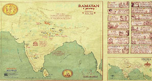
How did you come up with the Ramayana Map? What is its significance beyond being a collector’s item?
The Ramayana Map was my father’s idea. During the pandemic, he thought that we should use our mapping technology for something that could touch the heart of all Indians, that could combine our expertise with our cultural heritage. Our team has made a work of art map of ancient Akhand Bharat, mapping Bhagwan Rama’s journey from Ayodhya to Lanka, using accurate scale and ancient distance units on antique paper canvas. We have also given interesting trivia associated with every place, so the children can consume this knowledge in an interesting bite-sized way. Some schools have already ordered these, and we hope that more and more people, especially Indians living abroad, would keep these in their homes.
What are your future plans and new additions to your brand stack? What are some of the AI trends that you are excited about?
We stand for cutting-edge technology and are going to keep making headway there, but we are also excited about the government’s attitude towards tech. The Prime Minister has already called this decade ‘techade’, and it is exciting to see how we can work together to help Indians – like using geospatial technology for infrastructure development and deciding where roads, schools, and hospitals should come up. This can, in turn, be monitored with drones and the IOT. All of it can be well-planned and not random.
Let’s talk about the Start-up ecosystem in India. How exciting is it? If you were asked, what would be your three big tips to share with younger entrepreneurs and how to navigate the markets?
It would be best if you look to make a positive dent in the world. Look for a user base which is troubled by something, and then provide a solution in a cost-effective, unique and scalable manner. The third would be to run your business transparently and fairly.