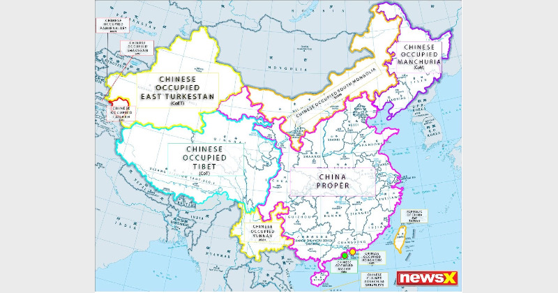

NewsX, a leading Indian news channel has released the real Chinese map which shows the original area of China and the territories and lands which it has illegally occupied and now claimed as its own. The the map being shared widely on social media #RealMapOfChina was trending on Twitter.
The map released by NewsX shows ‘China Proper’, the area which is traditionally China and without the regions it has occupied. The other areas shown in the map are Chinese Occupied Tibet (COT), Chinese Occupied East Turkestan (COET), Chinese Occupied South Mongolia (COSM), Chinese Occupied Manchuria (COM), Chinese Occupied Yunnan (COY), Chinese Occupied Macau (COMa), Chinese Occupied Hong Kong (COHK), Taiwan, and Chinese claimed parcels and spartleys.
The map also depicts the McMahon line and occupied areas of Bharat. Chinese Occupied Ladakh (COL), Chinese Occupied Shaksgam (COS) and Chinese Occupied Pamir Valley (COPV) are the areas belonging to India shown in the map. NewsX has requested cartographers to use the map in place of the one shared by China.
Some researchers opine that the Han ruled China is even smaller if the old regions of Goetsu, Hokkien and Cantonia (renamed as Guangdong by China) are not considered as they were not part of traditional China. There have been several freedom movements in China from citizens of these regions which have been occupied by China during the last century.
Among these freedom movements, the Tibetian independence movement, Manchuria independence movement, Shanghai independence movement, Cantonia independence movement are the prominent ones. China has crushed all these movement with brutal force, torture, extra-judicial killings and concentration camps.