
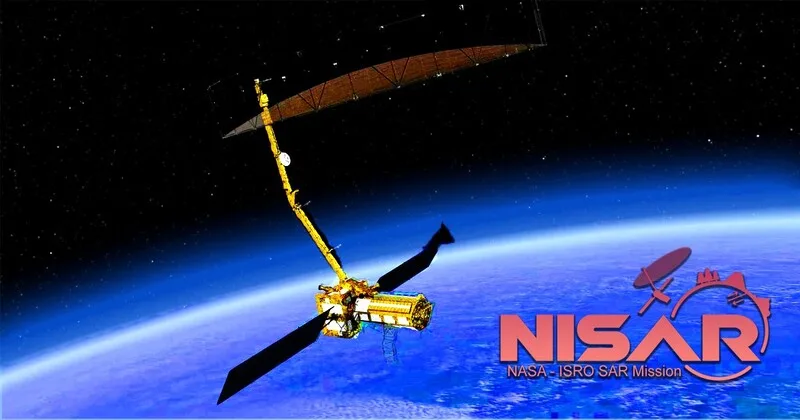
The joint NASA–ISRO Synthetic Aperture Radar mission, NISAR has crossed one of its most critical milestones of the flawless deployment with massive 12 metre radar antenna. With this achievement India and the United States have unlocked a new chapter in global Earth observation which will provide insights into climate change, agriculture, forests, water cycles, natural disasters and planetary ecosystems.
The antenna deployment is a high precision manoeuvre performed nearly two weeks after launch marks the formal completion of the spacecraft’s commissioning phase and the beginning of operational science. According to ISRO, the reflector and its 9-metre boom were launched in a folded configuration and opened through sequenced mechanical operations performed from the ISRO Telemetry Tracking and Command Network (ISTRAC) with constant coordination from NASA’s Jet Propulsion Laboratory.
Unfolding of a 12 Metre Wing in Space
The 12-metre diameter reflector is the key component of NISAR dual band radar system. It supports ISRO S-Band and NASA L-Band Synthetic Aperture Radar payloads together enabling high resolution for all weather Earth imaging.
Engineers waited for orbital conditions before commencing the deployment sequence after NISAR’s successful launch on the GSLV-F16 rocket on July 30, 2025. As the uploaded document suggests that the unfolding started on 9 August 2025, boom joints called as the wrist, shoulder, elbow and root were methodically opened over five days. On 15 August 2025, the reflector at the end of the boom unfolded and locked into operational configuration.
NASA had earlier underscored the complexity of this mechanism the largest deployable radar antenna ever sent into Earth orbit. US news outlets highlighted that similar structures had originally been developed for deep space missions but were adapted for Earth observation through the NISAR partnership.
Entering the Science Phase: First Image Reveal Godavari Delta Fertile Land
With the antenna was fully deployed, NISAR began test imaging across the Indian landmass and global calibration sites. Its first public S-Band image, taken on 19 August 2025 showcased the fertile Godavari River Delta in Andhra Pradesh. The image revealed mangroves, agriculture, aquaculture ponds, arecanut plantations and other vegetation classes with striking clarity. The scientists also remarked that such kind of detail would change the way river deltas and the crucial ecosystems sensitive to sea level rise and climate variability are monitored.
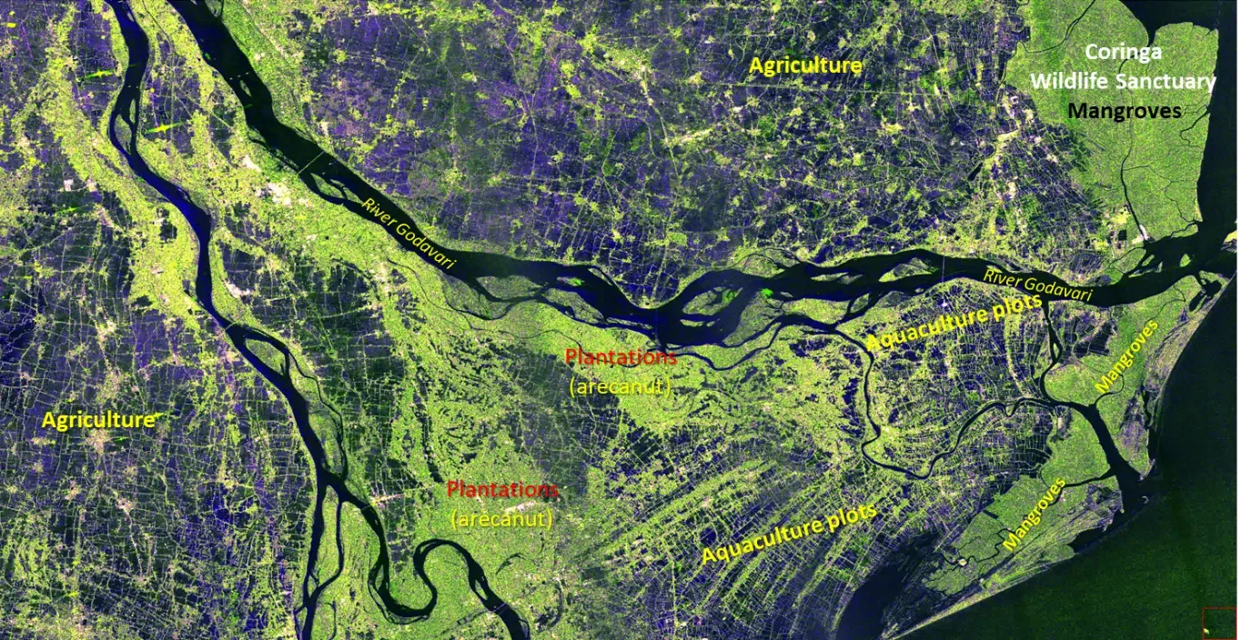
NISAR Generated Godavari Delta High Resolution Image
Data from Amazon rainforest sites were simultaneously used for fine tuning the spacecraft’s pointing and image calibration. Media reports noted that using Earth’s most biodiverse region for calibration helps validate NISAR’s ability to detect biomass, forest density and moisture levels parameters essential for tracking global carbon cycles. On NISAR’s 100th day in orbit, ISRO released a selection of S-Band images to the public thus marking the beginning of the mission’s science operations.
New Era of Global Earth Observation
NISAR is not just another satellite scientists call it as the most powerful radar mapper ever launched for Earth science. The mission will systematically map nearly the entire planet every 12 days using dual frequency radar, enabling
NISAR is emerging as a transformative tool across multiple domains, beginning with climate and cryosphere monitoring where its L-Band radar enables precise tracking of Himalayan and polar glaciers. Snow cover and ice sheets especially critical because optical satellites often fail under dense cloud conditions. It can also measure crystal deformation from earthquakes and landslides, strengthening early warning and geophysical assessments.
In agriculture domain NISAR’s dual band capabilities allow accurate estimation of soil moisture, mapping of crop growth cycles and detailed assessment of flood and drought impacts. Early S-Band data analysis already shows strong potential in crop classification across Indian states, reinforcing its value for government schemes like PMFBY and digital agriculture platforms. In forest and carbon accounting NISAR will provide high resolution data to measure biomass, forest regeneration and degradation. Supporting global carbon tracking systems essential for COP negotiations and emerging carbon markets. NASA has noted that the mission will deliver the world’s first consistent radar-based dataset for global biomass monitoring.
NISAR enhances disaster response through rapid imaging during cyclones, landslides, floods and earthquakes, with ISRO highlighting its ability to penetrate cloud cover, for an invaluable capability during India’s monsoon season when disasters are most frequent.
India–US Partnership Behind NISAR
NISAR represents one of the most ambitious technological collaborations between India and the United States. The radar payloads are jointly developed NASA leading the L-Band, ISRO the S-Band, while ISRO built the satellite bus and launched the mission. The deployable antenna system and boom were developed by NASA, while Indian engineers customised onboard electronics, data relay systems and imaging configurations.
The mission is also seen as a strategic symbol of growing Indo-US cooperation in space. Leading newspapers noted that NISAR’s timeline aligned with strengthened bilateral ties in technology, climate action and disaster resilience frameworks.
As NISAR enters its operational phase, scientists from both countries are preparing for a large number of data, that is expected to exceed several petabytes over the mission’s lifetime. Researchers believe this will revolutionise not only academic studies and will also support government planning across sectors like water resources, crop insurance, climate adaptation and infrastructure safety.
From monitoring Himalayan glaciers to mapping coastal erosion, to tracking forest carbon and strengthening disaster response, NISAR is set to become the world’s most comprehensive Earth monitoring platform for the next decade.
This complex unfolding of a 12-metre antenna drifting high above Earth, which is an engineering marvel and achievement that symbolizes global collaboration, scientific innovation and a shared commitment to understanding our changing planet.


Comments