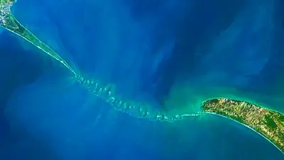
The Indian Space Research Organisation (ISRO) has successfully mapped the submerged structure of Adam’s Bridge also known as Ram Setu, an ancient bridge between India and Sri Lanka mentioned in Indian religious texts. The researchers used ICESat-2 Data from October 2018 to October 2023 to generate a 10-meter sufficient to capture details of a train size coach.
The detailed underwater map reveals the bridge’s continuity from Dhanushkodi to Talaimannar with a staggering 99.98 percent of it submerged in shallow waters. According to a study published in the Journal Scientific Reports, ISRO scientists used advanced laser technology from a US satellite to create a high-resolution map of the entire length of the submerged ridge.
The research team led by Giribabu Dandabathula, discovered 11 narrow channels that allowed water to flow between the Gulf of Mannar and Palk Strait and play a crucial role in preserving the structure from sea waves. The study confirms the origin of the Adam’s Bridge, also called Ram Setu, which was once a land connection between India and Sri Lanka. The findings provide new insights into the region’s history and the formation of this ancient structure.
The submerged structure was called Adam’s Bridge by an East India Company mapper. The structure, described as Ram Setu by Indians is mentioned in the Ramayana and the Ramcharitmanas as a bridge built by Bhagwan Ram’s army to help him reach Sri Lanka where Devi Sita was held captive by Ravana. Persian navigators in the ninth century AD referred to it as Sethu Bandhai or a bridge over the sea. Temple records from Rameshwaram indicate that the bridge was above sea level until 1480 when it was demolished by a powerful storm.
Earlier Satellite observations pointed out to the undersea construction. But these observations were primarily focused on exposed sections of the bridge. The sea in the area is very shallow ranging from one to ten meters deep in parts making navigation and ship mapping of the ridge very difficult and cumbersome.
Scientists claim that both India and Sri Lanka were once part of an ancient supercontinent called Gondwanaland that separated and drifted northward as an isolated giant island landmass in the Tethys Sea until it crashed into the supercontinent called Laurasia sometime between 35 million and 55 million years ago. Over millions of years, sea levels have risen and fallen, submerging and exposing the ridge.


Comments