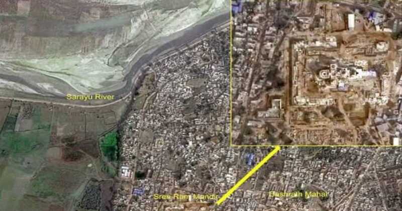
Ayodhya, the spiritual epicentre of India, is witnessing the remarkable progress of the grand Ram tMandir’s construction. In an unprecedented move, the Indian Space Research Organisation (ISRO) has unveiled satellite photos of the sacred site, showcasing the sprawling expanse of the Ram Janmabhoomi and the intricate construction of the Mandir. These images, captured by indigenous satellites from the Indian Remote Sensing Series, provide a unique perspective on the development, offering a bird’s-eye view of the sacred landscape.
The photographs, taken on December 16 of the preceding year, reveal the 2.7-acre Ram Janmabhoomi site shrouded in a blanket of fog. Despite the weather challenges, the images offer a clear glimpse of the ongoing construction, highlighting the significant progress made in the development of the Ram Mandir. The Dashrath Mahal and the tranquil Saryu River are prominently featured in the satellite photos, providing context to the historical and spiritual significance of the region. Additionally, the Ayodhya railway station is visible in the imagery, emphasising the connectivity of the sacred city.
ISRO’s contribution extends beyond providing captivating satellite imagery; the organisation’s technology has played a pivotal role in various stages of the Mandir’s construction. One of the major challenges faced during the project was the precise identification of the location for installing the murti of Sri Ram. The trust overseeing the construction aimed for a specific 3×6 feet space inside the sanctum sanctorum, believed to be the birthplace of Sri Ram.
This seemingly daunting task was navigated with the assistance of ISRO’s advanced technology. Contractors from Larsen & Toubro, the construction company entrusted with the Mandir’s development, leveraged a sophisticated differential Global Positioning System (GPS) for precise coordinates. The construction team meticulously prepared coordinates with an accuracy of 1-3 cm, serving as the foundation for the installation of the murti within the sanctum sanctorum. ISRO’s expertise in space technology thus played a crucial role in ensuring the alignment of the Mandir’s sacred elements with historical and religious significance.
The unveiling of satellite images by ISRO not only showcases the grandeur of the Ram Mandir construction but also underscores the integration of cutting-edge technology in the preservation of cultural and religious heritage. As India continues to make strides in space exploration and technology, such applications demonstrate the multifaceted contributions of space research to diverse fields, including heritage conservation.
The National Remote Sensing Center of the Indian Space Agency, headquartered in Hyderabad, played a key role in processing these images. The centre’s expertise in remote sensing technologies contributed to the clarity and precision of the satellite photographs, providing a valuable visual record of the ongoing transformation at the sacred site.
The collaboration between ISRO’s space technology and the construction of the Ram Mandir in Ayodhya exemplifies the harmonious blend of tradition and modernity. As the nation eagerly awaits the consecration of Ramlala in the completed Mandir, these satellite images serve as a testament to India’s prowess in space technology and its commitment to preserving its rich cultural heritage.