ISRO and NASA jointly develop NISAR Satellite to help in monitoring earthquake-prone regions in Himalayas
June 15, 2026
  • Read Ecopy
  • Circulation
  • Advertise
  • Careers
  • About Us
  • Contact Us
Android AppiPhone AppArattai
Organiser
  • ‌
  • Bharat
    • Assam
    • Bihar
    • Chhattisgarh
    • Jharkhand
    • Maharashtra
    • View All States
  • World
    • Asia
    • Europe
    • North America
    • South America
    • Africa
    • Australia
  • Editorial
  • International
  • Opinion
  • RSS @ 100
  • More
    • Op Sindoor
    • Analysis
    • Sports
    • Defence
    • Politics
    • Business
    • Economy
    • Culture
    • Special Report
    • Sci & Tech
    • Entertainment
    • G20
    • Azadi Ka Amrit Mahotsav
    • Vocal4Local
    • Web Stories
    • Education
    • Employment
    • Books
    • Interviews
    • Travel
    • Law
    • Health
    • Obituary
  • Subscribe
    • Subscribe Print Edition
    • Subscribe Ecopy
    • Read Ecopy
Organiser
  • Home
  • Bharat
  • World
  • Operation Sindoor
  • Editorial
  • Analysis
  • Opinion
  • Culture
  • Defence
  • International Edition
  • RSS @ 100
  • Magazine
  • Read Ecopy
Home Bharat

ISRO and NASA jointly develop NISAR Satellite to help in monitoring earthquake-prone regions in Himalayas

India-US Space Agencies develop a satellite that will prove to be a boon for seismologists and geologists in India

WEBDESKWEBDESK
Apr 17, 2023, 10:30 pm IST
in Bharat
Follow on Google News
FacebookTwitterWhatsAppTelegramEmail

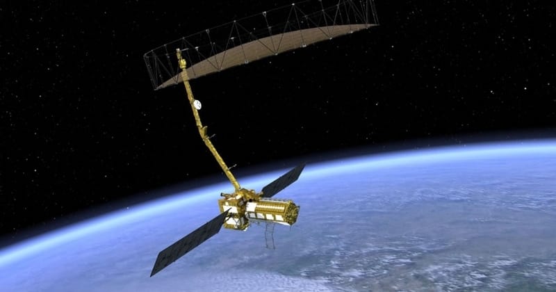
The Indian Space Research Organisation (ISRO) and NASA (National Aeronautics Space Administration) of the US has jointly developed a forthcoming satellite named NISAR (NASA-ISRO-Synthetic-Aperture-Radar) which will help in mapping the most earthquake prone regions in the Himalayas with unprecedented regularity.

The data generated will be instrumental in generating advanced potential warning of land subsidence which was recently observed in Joshimath (Uttarakhand).

According to Dr. Prakash Chauhan, director of ISRO National Remote Sensing Center, the NISAR satellite expected to cost approximately $900 crores (with ISRO contributing one tenth) will use two bands-L band and S-Band to image the seismically active Himalayan Regions, every 12 days and create a deformation map.

The geo-science community can use this data to determine how strain is building up in various parts of Himalayas. The two frequency bands will provide a high resolution and all-weather data to from the satellite to that is expected to follow a sun-synchronous orbit and will be launched in January 2024.

In geology, strain refers to the deformations that occurs in rocks when it is under pressure from other rocks. This happens due to movement of continental and tectonic plates that are sliding, colliding, or subducting against each other.

The perfect example is the creation of the Himalayas. When the Indian Plate collided with the Eurasian Tectonic Plate, resulted in the formation of the Himalayas and it incrementally pushes upwards.

Based on the intensity of the past earthquakes, the knowledge of speed at which the plates move, and the locations where the plates interact (faults) can help geologists and seismologists in finding out regions that are most vulnerable to earthquakes and can predict the spread of the tremors.

However, one crucial factor called timing cannot be deduced. The Ground Based observatories can record and can pick up underground waves that result from an earthquake and provide early warning.

In 2021, scientists from the Geological Survey of India (GSI) published a strain map of the Himalayas with the help of 1252 GPS Stations and identified certain regions where greatest odds of generating earthquakes above 8 on the Richter Scale and their extent.

While satellite imagery to study deformation in land is already employed, the frequency and clarity of the images are critical. V K Gahalaut of the National Geophysical Research Institute (NGRI) said- “With a frequency of 12 days and the ability to be able to provide images even under cloudy conditions, NISAR would be a valuable tool to study deformation patterns, such as in Joshimath”.

Land Subsidence or the loosening of the sub surface had caused the several parts of Uttarakhand to sink and this caused water to seep via cracks and crevices into houses”.

In 2021, a large landslide of rock and ice triggered a flood in Chamoli, Uttarakhand that claimed close to 200 lives and additionally destroyed two hydropower projects.

It was the Satellite imagery that helped scientists decipher the cause of the flash floods.


Topics: Geological Survey of India (GSI)NASAISROHimalayasland subsidenceearthquakes
Share6TweetSendShareSend
✮ Subscribe Organiser YouTube Channel. ✮
✮ Join Organiser's WhatsApp channel for Nationalist views beyond the news. ✮
Previous News

Sudan Crisis: Indian national dies due to stray bullet injury; Jaishankar says ‘situation remains of great concern’

Next News

Kids spend more hours before screen on holidays compared to school tenure: Study

Related News

Saree worn by India's Rocket Woman Nandini Harinath displayed at US Space Museum

From Mangalyaan to USA: ISRO scientist Nandini Harinath’s iconic ‘Mars Mission Saree’ featured at US Space Museum

India’s Chandrayaan-2 Helps Reveal Water Ice in the Moon’s Shadowed South Pole

How ISRO’s Chandrayaan-2 gifted the world moon water; The orbiter that changed lunar science forever

Mountaineer Arun Kumar Tiwari’s tragic death on Everest; Family says he reunited with Bhagwan Shiva in Himalayas

A representative image

National Jute Board expands ISRO-backed digital crop monitoring system to strengthen jute sector planning

Representative Image (This is an AI generated image)

National Technology Day 2026: Mapping India’s rise from nuclear power to digital leader

GalaxEye’s mission Drishti launch marks a defining leap for India’s private space sector with world’s first OptoSAR satellite

Mission Drishti: GalaxEye deploys India’s largest private satellite with breakthrough all-weather imaging capability

Load More

Latest News

Addressing the second day of Vijnana Bharati’s 7th National Convention at BHU, RSS Sah Sarkaryavah Dr Krishna Gopal

Vijnana Bharati’s 7th National Convention | Scientists must work to harmonise spirituality & science: Dr Krishna Gopal

Representative image

West Asia Conflict: Donald Trump announces landmark US-Iran agreement, raises hopes for peace

Keralam: CM VD Satheesan Faces Backlash for Criticising VCs Attending RSS Programme Addressed by Dr Mohan Bhagwat

Prime Minister Narendra Modi: Record maker and breaker

India surpasses South Korea, Enters big 5 manufacturing hub; Seals strategic footprint in the global supply chain

Gujarat: Married Man Karim Rafik Posed as Widower 'Aditya Patel' to Trap Hindu Women; 8,000 Photos and Videos Found on Phone

Gujarat Matrimonial Fraud: Karim posed as widower ‘Aditya Patel’ to target Hindu women; 8,000 photos found on phone

A suicide bomber attacked the Jhangi police checkpost in Taunsa Sharif, Dera Ghazi Khan, Punjab, near the Khyber Pakhtunkhwa border

Khyber Pakhtunkhwa: TTP suicide bomber hits police checkpost, two Pakistani policemen killed

(Left) BJP leaders R Ashok (Right) BY Vijayendra

Karnataka: Guarantee schemes revision exposes Congress failure; BJP alleges secret plan to slash beneficiaries

Unnao: Clash Erupts Over Alleged Illegal Madrasa on Government Land; Hindu Activists Claim Attack During Visit to Site

UP: Clash erupted over illegal madrasa on government land in Unnao; Hindu activists injured, police deployed

PM Modi welcomed in Slovakia with rendition of 'Vande Mataram'

Historic Visit: PM Modi becomes first Indian PM to visit Slovakia, welcomed with rendition of ‘Vande Mataram’

Load More
  • Privacy
  • Terms
  • Cookie Policy
  • Refund and Cancellation
  • Delivery and Shipping

© Bharat Prakashan (Delhi) Limited.
Tech-enabled by Ananthapuri Technologies

  • Home
  • Search Organiser
  • Bharat
    • Assam
    • Bihar
    • Chhattisgarh
    • Jharkhand
    • Maharashtra
    • View All States
  • World
    • Asia
    • Africa
    • North America
    • South America
    • Europe
    • Australia
  • Editorial
  • Operation Sindoor
  • Opinion
  • Analysis
  • Defence
  • Culture
  • Sports
  • Business
  • RSS @ 100
  • Entertainment
  • More ..
    • Sci & Tech
    • Vocal4Local
    • Special Report
    • Education
    • Employment
    • Books
    • Interviews
    • Travel
    • Health
    • Politics
    • Law
    • Economy
    • Obituary
  • Subscribe Magazine
  • Read Ecopy
  • Advertise
  • Circulation
  • Careers
  • About Us
  • Contact Us
  • Policies & Terms
    • Privacy Policy
    • Cookie Policy
    • Refund and Cancellation
    • Terms of Use

© Bharat Prakashan (Delhi) Limited.
Tech-enabled by Ananthapuri Technologies