
Assam Floods/ Analysis
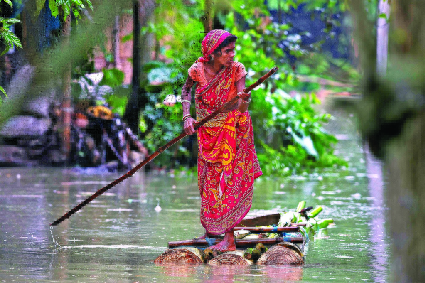
A woman rows a makeshift banana raft through flood waters in Burgaon, east of Gauhati, Assam
Chronic incidents of natural disasters like flood fury and earthquakes with regard to Assam has been aggravated by sheer human greed and their callous attitude to Mother Nature’s scheme of things. When shall we humans learn to live in harmony with Nature to avert natural disasters?
Come Monsoons in June, the fury of floods in Assam becomes the “Breaking News Headlines” in almost all TV Channels. 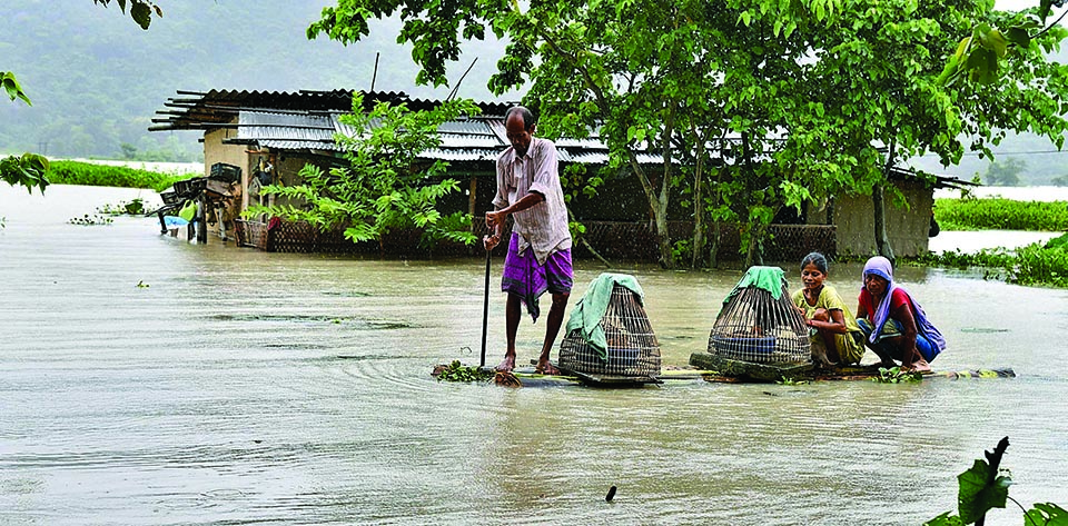

Assam is in the grip of yet another flood fury, with 59 dead and 48.87 lakhs people affected in 28 of the 33 districts of the state as per Assam State Disaster Management Authority (ASDMA) report in media. In terms of impact on human lives, the floods of 1988, 1998, 2004 and 2012 were the worst; the 2004 floods alone affected 12.4 million people and claimed 251 lives.
Floods are a regular annual feature in Assam. As per experts, Assam experiences two to three flood waves until the end of the rainy season, which will last till mid-October. This is the first wave of floods this monsoon, and flood control experts expect at least two more.
In reality, annual floods in Assam are mostly man-made ones — deforestation, population growth in catchment areas, habitation in adjoining low lying areas, earthquakes and landslides and large road construction activity. Sometimes floods cause more destruction than others.
Why are floods so destructive in Assam? The reasons for destructive floods commonly identified by environmentalists include: heavy rainfall spells during monsoon; discharge of 19,830 cubic meters of water per second, that is, fourth ranked in the World; and, annual sediment yield of 1,403 tons per sq km with 804 tons per sq km at Pandu of Guwahati.
And, the prime reason for the vast sedimentation is ascribed to Tibet that is cold, arid and lacks plantation, which is patently wrong. But, what about sedimentation due to barren hills South of Watershed in Arunachal Pradesh and from North of Patkoi Range due to deforestation? Ascribing the reason for floods to Tibet is just indulging in ‘blame games’ on the neighbours.
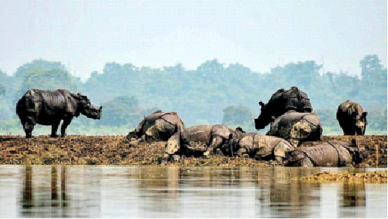
Rhinos trying to reach higher grounds at the Kaziranga National Park surfaced
With the glaciers and snow meltdowns, soil erosions result in vast silt flowing downstream. With the first outbreak of Monsoon rains nowadays, water gushes rapidly from numerous tributaries into the Brahmaputra in Assam valley carrying with it large sediments from the hills. Naturally, vast amounts of silt get deposited in the riverbed creating temporary sandbars or river islands and resulting in changes in the river course. Following gushing waters gnawing away at embankments and bunds, adjoining low-lying areas and inhabitations get submerged. There is nothing new about the above phenomena – pure and simple Nature’s Law.
Media barely goes into the causes of floods except for sensationalising episodic incidents. Look at the fraud reported in the media – China’s failure to provide meteorological data is responsible for the fury of floods in Assam. In the recent past, there is also controversy stirred by sensational news coverage on the first “Dam” constructed by the Chinese that became operational for power generation in 2015 upstream in Tibet – the Zangmu Dam on the Yarlung Zangbo/Tsang Po/Brahmaputra River 9 km (5.6 mi) northwest of Gyaca built a few kilometers from the Bhutan- India border.
Let me highlight the data of annual precipitation in Lhasa that is relatively high for Tibet at 500 millimeters (50 centimeters), whereas the annual precipitation across the region averages around 200 millimeters (20 centimeters). Most of the rainfall happens between June-September. Barely, there is rainfall during other months.
In contrast, the highest annual rainfall for individual station south of the Himalayan Watershed may exceed 5000 millimeters (500 centimeters) and average number of rainy days (days with rain of 2.5 mm. or more) ranges from 100 at Thangu in North Sikkim to 184 at Gangtok in east Sikkim. Almost 10 times more than in Tibet!
De facto, the maximum rainfall is on the South of the Himalayan watershed year after year. Even a layman would laugh at the media blaming China or other nations for the fury of floods in the States of Assam, West Bengal, Bihar and UP.
Yet another reason attributed is the earthquake-prone nature of the region that is responsible for the rivers’ unstable character. Following the devastating earthquake of 1950, the level of the Brahmaputra rose by two metres in Dibrugarh area in eastern Assam.
Having lived in Mechuka and Tuting close to McMohan line in Upper Siang in Arunachal Pradesh during 1961-1962, Nagaland during 1963-1964 and 1985-1988 and Assam during 1994-1995, let me provide first hand experiences of monsoons and floods. In particular in Mechuka where 30-40 days of clear skies in a year is viewed as nature’s bounty.
My first exposure to centuries-old primary forests – Nature’s Gifts – dates back to 1961, when I first started climbing the mountains to go on patrolling to the McMohan line. It used take me at least 30-40 minutes to reach and see the canopy of the tree at the top. With such a green canopy, only driblets of rain used to fall on us even when there was heavy rain.
And, the foliage under the trees and bushes used to absorb the rainfall. Nature used to control its steady flow into streams and rivulets. So, in the first monsoon rains in May-June, tributaries were rarely flooded. Mostly the water used to be crystal clear. River water flows getting muddied due to sedimentation was mostly restricted to monsoon period during July-September. Today, all that has changed dramatically due to human greed.
A flood affected family stands on a banana raft near their submerged house in Burgaon, east of
Gauhati, Assam
Gauhati, Assam
Next, human greed is the prime reason for the repetitive annual devastation and destruction. Over the past 60 years, deforestation of large tracts of primary forests – tropical, sub-tropical, temperate, pine and alpine forests at various altitudes besides bamboo forests and grasslands – has been carried out in connivance with local political leaders by “Veneer and Saw Mills besides Plywood factories”.
In reality, uncontrolled deforestation is the main reason for devastating floods year after year. During my tenure in Mon District of Nagaland during 1985-1988, I was witness to devastation of centuries-old primary forests, particularly Hollong trees that grows naturally in forests of upper Assam and Arunachal Pradesh considered as the State Tree of Assam and sacred tree for Moran community.
Today, Hollong forests are virtually denuded as they have been exploited for manufacturing plywood to decorate chambers and furniture. Similarly, centuries-old Holok trees have been cut for use by plywood industries. Over 75 Veneer and Saw Mills operated in the foothills of the Assam-Nagaland border in Mon District. Subsequently, I also witnessed its spread to Arunachal Pradesh during 1995-1996 and the spread of deforestation with utter disregard to its adverse environmental fallout spread to all the Hill States to include Meghalaya, Mizoram, Manipur and even Sikkim. Similarly, deforestation of all other species used as fillers in making plywood.
Due to logging, mostly illegal and some legal, canopy cover and foliage water retention capability has substantially diminished. Its fallout is soil erosion resulting increased quantities of sludge flows into the main river resulting in changes in the course of main channel of rivers. With silt/sludge sedimentation drastically depositing in the main channel and reducing its depth and its capacity for flow of water, floods are natural what with swirling waters cutting into the banks, breaching bunds and overflowing inundating low lying areas devastating and destroying all that falls in their way.
Yet another significant factor to note is three to four times increase in population. For example, population of Assam in 1951 was only just over 80 lakh; but increased to 3.2 crore in 2011, that is, fourfold increase. Less known is the fact that majority of the tea estates have been developed on elevated terrain features. Perforce, restricting space for human habitations to low-lying, flood prone areas is quite common. When rainfall is heavy and river banks are breached low-lying areas get inundated resulting in flooding of human habitations and destruction and death to humans and animals.
Also, in the early decades of Independence, people lived mostly in eco-friendly “Bamboo Houses” made on “Silts” as proactive and pre-emptive safety and security measure. With three to four fold increase in population and in the name of growth and development, human habitations – cement jungles – have been developed in low lying areas prone to inundation. Who is responsible for such thoughtless growth?
Related News


Latest News