Academic scholars present a study on the future of religious demography of some sensitive spots in the Northern arch where Hindu population is on a sharp decline
This article has been co-authored by Shanmukh (@maidros78), Aparna (@a_r_j_u_n), Vikram (@TrueIndology), Arihant (@TheMedicalActivist), Saswati Sarkar (@sarkar_swati), and Dikgaj (@dikgaj)
Introduction:
In the previous articles, we have the analysed the demographic situation in Western Uttar Pradesh [8], West Bengal [9], Assam [10], Kerala and southern Tamizh Nadu [11], and Jammu and Kashmir [12]. In these articles, we showed that in the next fifty years the Hindu population stands to fall below the 50% mark (or at least close to it) in many regions of interest we considered, using various mathematical models. In this article, we will consider the other regions in the Hindi heartland where the Hindu population is shrinking sharply, due to rising Muslim population (and in place, Christian population, too, in addition to the Muslim population). In particular, we have discussed, in this article, the shrinking Hindu population in parts of Jharkhand, Bihar, Uttar Pradesh, Haryana and Rajasthan outside the Muslim belt of West Uttar Pradesh and Southern Uttarakhand which has been studied in [8]. Further, we also examine these regions and see if there is a pattern to these changes, and what the pattern portends pertaining to strategic security interests, if there is one.
For the sake of historical consistency, we have grouped the following districts together, as they existed in 1951. In this article, moving from East to West, Santhal Parganas comprises the current districts of Deogarh, Pakur, Sahebganj, Godda, Dumka and Jamtara, Purnea comprises the current districts of Purnea, Ararea, Kishanganj and Katihar, Bahraich-Gonda comprises the districts of Bahraich, Shravasti, Gonda and Balrampur, and Gurgaon comprises the districts of Gurgaon, Faridabad and Mewat.
In all our computations, we have grouped the Hindus, Jains, Sikhs, Animists and Buddhists together. In the districts under consideration, the Jains, Sikhs, and Buddhists are vanishingly small (<0.5%) in all the districts. The Animists that are present in Jharkhand are a little inconsistently recorded (sometimes as Hindu and sometimes as the local Munda religions) and the Jains were recorded as Hindu often, in the 1951 and 1961 census, in Bahraich and Gonda.
Before delving into the statistics of religious demography, we present a brief history of evolution of religious demography of the regions under consideration.
Section A: History of Abrahamization of hubs of the Hindi Belt
Section A.1: Santhal Parganas
Santhhal Pargana is being Christianized and Islamized as a direct consequence of Hindu merchantile greed, exploitation by Hindu landlords and Islamist quest to colonize the available land of weak tribals devoid of any political support. Ironically, the Abrahamization has been more intensive after the transfer of power in 1947 as opposed to during the British Colonial times. We provide the details below.
Santhal Paraganas are bordered by Birbhum, Murshidabad and Maldah in the east, and the (old) Purnea in the north and are thus sandwiched between to Muslim heavy areas. Originally, in Santhal Parganas, the entire region, except for a small alluvial strip on the west bank of the Ganga, was inhabited by Santhals, Paharriya and other tribals [13]. They ruled the region even during the Mughal times and the Mughals, seeing little reason to engage in warfare with them, left them alone, securing the Damin-i-Koh (route from the upper Ganges valley to Bengal) via the Teliagarhi fortresses. The west bank of the Ganga was inhabited by the Bengali Zamindars, both Hindu and Muslim, all the way from Tappa Manihari to Pakaur [13]. The first clashes began between the tribals and the Zamindars in the 1780s p. 42, [13]. However, in the early-mid 1780s the EIC sent a sensitive official named Cleveland, who cut down the worst of the abuses, bribed the tribals with cloth and money, and sent missionaries to tame them pp. 44-48, [13]. However, after his early death, the fighting heated up again, when under an EIC official, Abdul Rasul Khan, known as Con Saheb, the tribals were brutally exploited. The tribals fought back ferociously and the fighting escalated with basketfuls of tribal heads being taken to the collector of Birbhum for a price p. 42, [13]. In the mid 1820s, the EIC tried reconciliation again, and tried to curb abuses, but the entry of Bengali Mahajans, Marwari and other Bihari moneylenders, and corrupt daroga officials, the exploitation of the tribals increased manifold, leading to the Santhal revolt of the 1850s pp. 51-57, [13]. When it was suppressed, the British EIC first and later the crown, decided to tame the tribals and sent in the missionaries to convert them to Christianity. Many missionary groups entered between 1859 and 1875 and the conversion was attempted pp. 63-80 [13]. However, till 1951, only about 0.17% of the district was Christian. But in the post independence era, the region has been invaded by Bihari Muslims from the north and the Bangladeshis and other Bengali Muslim groups from the east, so that both Sahebganj and Pakaur are in imminent danger of turning into Muslim majority districts in the next 50 years, and even Godda is showing a sharp fall in the number of Hindus and a corresponding rise in both Christians and Muslims. Further, since 1991, the Christian groups are also making headway and the number of Christians has grown by 3.5 times in the last 20 years between 1991 and 2011 (see graphs for Santhal Paraganas district in the Constant growth section).. The rapid rise of both the Muslims and the Christians at the expense of the Hindus leaves the Hindus vulnerable in this district. The collapse of Hindus has serious security implications which we discuss subsequently.
Section A.2: Purnea
The Islamization of Purnea is again a consequence of conversion by Sufis operating under the political protection of the Mughals, settlement of Muslim peasants to bolster Hindu merchantile profit and appeasement of Muslims by political parties post the transfer of power in 1947. We trace the history below.
The Purnea district, which borders Dinajpur in the east, is a natural extension of the Murshidsbad-Maldah belt of West Bengal. The region was never really conquered until the Mughal times and had been ruled by the Koch-Rajbongshi tribes, especially east of the Kosi. Aided by geography and the short campaigning period available for actions against them, Koch-Rajbongshi tribes put up a ferocious resistance to conquest against the Bengal Sultanate and the Mughals. However, when the Koch-Rajbongshi tribes were temporarily defeated in the 17th and 18th centuries, Sufis obtained significant conversions. The region has a high, Muslim population due to the conversion of some of the Maithili and Koch-Rajbongshi population in the area during the Mughal and Bengal Nawab times. Indeed, the Purnea District Gazetteer of 1908 observes that the Muslims presumed to descend from the Koch-Rajbongshis still follow a mixed tradition of worshipping both Hindu Gods and Goddesses such as Devata Maharaj and Bishahari-mai p.74-76. [2] . The Muslim population was augmented in the Katihar and Purnea regions by the introduction of a large number of Bihari and Bengali Muslim peasants in the 1800s to grow indigo in the newly claimed regions. p. 138, [2]
The region (along with Maldah and Dinajpur) witnessed the migration of Muslim peasants to East Pakistan (currently Bangladesh) during Partition, but many of them returned in the wake of the Nehru-Liaqat agreement which was essentially intended to protect the Muslim retunees. Many of these Muslims peasants who had left for East Pakistan had supported the Partition. They spoke Urdu and had assumed that West Pakistan’s Urdu dominance would apply in the erstwhile East Pakistan as well. However, the Urdu-advocating Muslims were received with animosity in East Pakistan, which intended to maintain a Muslim religious and Bengali linguistic identity [23]. Cross-border migration had attendant atrocities as well. The Nehru-Liaqat Pact was signed on 8th April 1950 to “protect religious minorities, provide a safe passage to them’’, and to ensure that “looted properties would be returned and forced religious conversions would be de-recognized” [24]. It is evident from the sharp rise of Muslim population in the region between 1951-1961, as shown by Census numbers, that under the cover of “safe passage intended for the religious minorities”, the Urdu-advocating Muslims returned. Specifically, the (then) united Purnea district (along with the united Dinajpur and Maldah) districts witnessed a sharp rise in Muslim population between 1951 and 1961 [21]. To estimate the number of Muslims who returned to Maldah and Dinajpur in the wake of the Nehru-Liaqat Pact, we estimated the number of expected Muslims in Maldah and Dinajpur using the growth West Bengal Muslim growth rate for the 1951-1961 decade and subtracted this expected number from the actual number of Muslims present in these districts in 1961 as reported by Census. We similarly estimated the expected number of Muslims in Santhal Paraganas and Purnea using the Muslim growth rate in Bihar for 1951-1961 decade. This estimate shows that approximately 250,000 Muslims returned to Purnea, and 75,000 to Santhal Parganas, 150,000 Muslims returned to Dinajpur in West Bengal and about 90,000 to Maldah. Nationwide, it was estimated that a total of nearly 1 million Muslims returned to India in the wake of the Nehru-Liaqat Pact [21].
Environment conducive to the reciprocal return of Hindus to Pakistan, East or West, and current Pakistan and Bangladesh have not however been created, as a result, the Hindu population of East Pakistan which is currently Bangladesh, have witnessed a sharp and steady decrease over the years, and the minuscule percentage of Hindus registered in Pakistan post 1947 has not increased either.
Section A.3: Bahraich-Gonda
The Islamization of Bahraich-Gonda was a consequence of Muslim conquest that enabled colonization of land by aristocratic Pathan and Arabic settlers who converted the Hindu peasants through a combination of economic incentives and compulsion (eg, by denying them the liberty to practice their religion). Tragically, the resistance of Hindu peasants to the Muslim invaders were curbed by Hindu princely allies (from other parts of India) of these invaders. The historical details follow.
Old Bahraich and old Gonda are two districts on the Nepal border of Awadh. To the north, they are bounded by Nepal, to the east, by (old) Basti, to the south by Bara Banki and Faizabad, to the south west by Sitapur and to the west by Kheri. The region around Bahraich had a thick forest cover; even today, Bahraich district has a forest cover of 14.64 %. [5]. Yet, the forest covered was cleared early and settled by Indic tribes. In fact, Bahraich denotes the easternmost extent of Painted Grey Ware PGW culture (c.1000 BCE) p.15, [6]. Subsequently, the city of Sravasti in Bahraich became deeply associated with Hindu, Jain and Buddhist traditions. However, Sravasti seems to have been the only urban centre around the site. It housed considerable number of sannyasis who eventually trekked into the highland forests (yoga). The site was abandoned by 700 CE. The region continued came to be contested between Kannauj and Gauda.
Eventually, at the advent of Islam, Bahraich was ruled by Kalachuri rulers Gangeyadeva and his son Karna. Bahraich first came into Muslim hands during the campaign of Bakhtiyar Khilji (c.1206) [7]. However, only the town seems to have come into their hands and the forest zone seemed to have still been independent. Every now and then, the forest chieftains descended on the town and plundered it. Thus we hear that prince Nasiruddin Mahmud(c.1230), son of Iltutmish, “overthrew and sent to hell the accursed Bartuh under whose hands and sword more than one hundred and twenty thousand Musulmans had received martyrdom” [7]. Sultan Nasiruddin Mahmud fought “in that country and in the hills many battles against the infidels” [7]. It was Balban who seems to have finally subjugated these infidel tribes of Bahraich for we hear that under him “ decrees of fate the fortune of the Turks now triumphed, and the power of the Hindus was levelled with the dust” [7]. The early chroniclers (Utbi,Juznani, Minhaj) are completely silent about Salar Ghazi and his tomb at Bahraich. The first reference to Salar Ghazi's tomb comes from Ibn Babtuta. In the year 1340 Muhammad bin Tughluq performed a pilgrimage to Bahraich, accompanied by Ibn Battuta, who described not only the legends connected with the saint, but even some of the details of his cult, and in particular, the ritual of the veneration of the saint’s banner and spear. Sikandar Lodhi forbade this practice and also banned women from entering the saint's tomb. It is seems fairly clear that Salar Masud's tomb became a popular place of pilgrimage for Muslims by 1350. In Ain-i-Akbari, it is mentioned as a land which housed rebels.
Further, Bahraich was considered a banjar (uncultivable) land . It was starting from the Mughal days well into the days of Nawabs that there had been a constant migration of Pahtan tribes to this country. The Pathans of early mughal days were rebels who fled east further from the centre of Mughal power. During the days of Awadh Nawab, many Pathans were enlisted as mercenaries in the army. As a result, pathans formed 36% of Ashraf castes who in turn formed 33 % of Muslim population of Oudh (1891 census) However, Bahraich would no more be a banjar land in the future. The process had already begun. It was in the 14th century that the earliest Sayyid families migrated to Bahraich. The Sayyids as supposed descendants of Prophet Muhammad were highly esteemed in Muslim world. One of the Muslim houses asserted their descent from Sayyid Taj, said to have emigrated from Arabia in the mid-fourteenth century. Another one traced itself back to Sayyid Ahmad, also from Arabia. Most of these Sayyid families were invited and granted settlements by the Muslim rulers to maintain their own legitimacy. The Mughal monarchs often granted revenue from land to religious scholars, mystics, and Sayyid or other noble families. These land grants subsequently led to an increase in the demand of land. Sayyids and other Muslim Shaikhs became the de-facto zamindars. For example, In Bara Banki, Muslim Shaykhs and Sayyids owned almost half the villages, though they constituted only 2.6 and 0.6 percent of the district's population, respectively, in the late nineteenth century. Deforestation, agricultural expansion and religious persecution followed. The Sayyid landowners sought peasantry among the locals and didn’t let them build their temples. Thus began the process of Islamization of natives.
In Gonda district, the early dynasties of Doms seem to have been extinguished by Sultanate under a Rajput adventurer from Gujarat named Sahaj Singh and his Pathan troops/allies. The Rajput adventurer established the Kalhan house that ruled the region till the mid 1500s. However, the Kalhan house was destroyed in a massive flood p. 87, [15] and the new rulers (Bisens and Kakar Pathans) were established in the region. However, large tracts of the districts were forested and the swamps malarial, so the population was low. Under Akbar, the region was given to Pathan Zamindars, who were to provide 1500 foot and 50 horse p. 143, [15]. In 1773, the Gonda estate was taken over by the crown of Awadh and Bahu Begum's eunuch brought in a large number of settlers to clear the forests and cultivate the lands. p. 155, [15]
The depredations on Hindus increased under Khwaja Ainuddin in the last years of the 18th century in both Bahraich and Gonda p. 149, [15]. However, in the 19th century, many swamps were cleared, and land reclaimed, and this brought in a large number of richer Muslim landowners (both under the Nawabs of Avadh and the British), which considerably enhanced the Muslim population in both Bahraich and Gonda [15]. The Muslim population of Bahraich jumped from 12.7% in 1869 to 18.4% in 1901 p. 65, [16], due to the arrival of the new cultivators. It has been observed that it is in Bahraich and Gonda that Muslim cultivators abound p. 72, [16], whereas in other parts of Awadh, they are either zamindars or engaged in other trades, but not often actual cultivators. Nevertheless, the long and direct Pathan rule of Utraula and parts of Tulsipur (via Pathan Zamindars) is one of the major reasons for a higher Muslim population of the Gonda district, while the Pathan and Sayyid estates of Nanpara and Ambhapur have contributed significantly to the Muslim population in Bahraich. The Pathan and Sayyid estates often converted their cultivators.
Section A.4: Gurgaon
The Islamization of Gurgaon is a consequence of forced conversions during Islamic conquest, rejection of a nominally Muslim clan by other Hindu castes and radicalization by fundamentalist Muslim organizations.
The bulk of the Muslims of Gurgaon are Meo Muslims who live in the southwest of the region, which is called Mewat. The Meos were originally a branch of the Chauhans at the north eastern corner of the Aravallis, stretching across south western (British) Gurgaon and the (then) princely states of Alwar and Bharatpur. The Meo Muslims were Muslims nominally, till the 1880s, when the Anjuman tried to radicalise them [17], [18]. However, their efforts didn't bear much fruit and till the 1920s, they remained mostly indifferent to Islamic preachers. Then the Arya Samaj and the Tabligh entered the scene, with the former trying to turn them into Hindus and the latter make them observant Wahhabi Muslims [17]. There was too much Hindu resistance from other castes that didn't want them back and consequently, the Tablighis won out. Further, in 1932, there began a peasant revolt, that took on a very Islamic character, and the Meos turned more radical [17]. And in 1946, incited by Maulana Abdul Kaddus – a man associated with the Muslim League – the Meos refused to pay taxes in Alwar and Bharatpur, and when it appeared that Punjab and Bengal would be given in their entirety to Pakistan, began to agitate for Meostan, that would merge with Pakistan pp. 322-323, [19]. The riots began in both Gurgaon and the Princely states of Alwar and Bharatpur, in which, a combination of Hindu castes chased out the Meos from all over the region and about forty to forty five thousand were forcibly converted to Hinduism p. 333, [19]. However, some Meos were returned to their homes from Pakistan by the efforts of Vinoba Bhave, and with the Hindu reluctance to accept them as Hindus, their own desire to have a unified community (which would be impossible if some were Hindus and others Muslims) and the Tablighi influence, the entire community turned to hardcore Islam in the subsequent decades. Now, the entire region is an Islamic stronghold and has a fast rising crime graph too [20].
Section B: Take Home Messages
Section B.1: Take Home Message 1: Shrinking Hindu Populations in hubs of Hindi Belt
We show using multiple statistical models that both the districts of Purnea and Santhal Parganas will become Hindu minority (or close to it). The Hindu population in the Santhal Parganas has been under a double attack, by a rapidly increasing Muslim population in the Sahebganj, Pakur and Godda regions and a swiftly rising Christian population everywhere in the districts except for Deoghar and Jamtara regions. Sahebganj and Pakur districts of the erstwhile Santhal Pargana will be Hindu minority soon. In Purnea, Kishanganj is already Hindu minority (31% Hindu) and Hindus in Ararea and Katihar are barely above the 50% mark (56% and 54% respectively). In the current Purnea district too, the Hindu population is falling sharply and the entire (old) Purnea is set to be Hindu minority by 2041. In Bahraich-Gonda composite district, Balrampur will be Hindu minority soon, while both Bahraich and Shravasti districts will be less than 60% Hindu. Similarly, in the Gurgaon, which is just South of Delhi, Mewat district is already less than 30% Hindu and the trend is set to accelerate in future, with tehsils of Faridabad becoming Hindu minority. In Gurgaon, the Hindu percentage has been falling despite huge influx of Hindu migrants from other parts of India from the 80s.
District | Actual Hindu Percentage | Predicted Hindu Percentage in 2061. | |||
| 1951 | 2011 | Constant Growth | Polynomial | Logistic |
Bahraich-Gonda | 78.90 | 70.72 | 65.61 | 66.56 | 65.41 |
Purnea | 69.93 | 53.86 | 44.71 | 45.39 | 49.19 |
Santhal Parganas | 90.39 | 73.01 | 41.48 | 52.69 | 60.14 |
Gurgaon | 83.04 | 76.15 | 68.18 | 74.99 | 70.71 |
Table 1: The Table shows the actual Hindu population in 1951 and 2011 and the projected Hindu populations in 2061 using the three methods named.
Districts | Constant Growth | Polynomial | Logistic |
Bahraich-Gonda | – | – | – |
Purnea | 2041 | 2041 | 2051 |
Santhal Parganas | 2051 | – | – |
Gurgaon | – | – | – |
Table 2: Date by which the districts will become Hindu minority, according to the different models
The point in all the cases is that the Muslim population percentage is essentially nearly doubling in almost all the districts under consideration. We have depicted the projected changes in Abrahamic population since 1951 using the three models. The projected population of Christians in Santhal Paraganas in the constant growth model is likely an overestimate. However, it is pertinent to remark that, in old Santhal Parganas, Muslims are tripling, and Christian percentage is rising 50-75 fold.
Districts | 1951 Population | Constant Growth | Polynomial | Logistic |
Bahraich-Gonda | 21.09 (M) | 34.39 (M) | 33.43 (M) | 34.58 (M) |
Purnea | 30.06 (M) | 55.08 (M) | 54.6 (M) | 50.8 (M) |
Santhal Parganas | 9.43 (M) /0.17 (C) | 28.35 (M) /30.16 (C) | 35.09 (M) /12.21 (C) | 30.9 (M) /8.95 (C) |
Gurgaon | 16.95 (M) | 31.81 (M) | 25 (M) | 29.25 (M) |
Table 3: The percentage of Muslims and Christians (shown after the slash, where applicable) in the different districts for 1951 and the projected percentages in 2061 using the three mentioned techniques
Section B.2: Take Home Message 2: The Mughalistan Corridor – Truth or Hype?
A lot has been written on the Mughalistan `conspiracy theory', both by the proponents and the opponents of the theory. For the proponents, it is plan to Partition India again. India north of the Ganga, they aver, is in the Islamist crosshairs. For the opponents, it is another conspiracy theory by the lunatic right wingers, who simply cannot stop stoking the paranoia over the Muslim population.
In order to examine this claim, we need to take a step back and look at the history of the sub-continent. Jinnah demanded a corridor of a thousand miles to connect east and west Pakistan p. 162, [1]. His goal was clear – he intended to create a Muslim safe passage between the two wings, in order to have a safe transit of goods, people and other items of interest between the two wings. Based on this corridor idea, many people have postulated that another partition of the subcontinent is envisaged by the promoters of the idea. While such a Partition may only be possible in the distant future, we cannot foresee another demand for a separate Muslim homeland in the immediate future that would create a corridor from Pakistan to Bangladesh. The regions involved are heavily non-Muslim and consequently, do not permit such a division by demographics, in the next 50 years. However, is it possible to connect the two Muslim homelands in the subcontinent by establishing a `safe corridor' between the two wings? This is an idea we explore in this article.
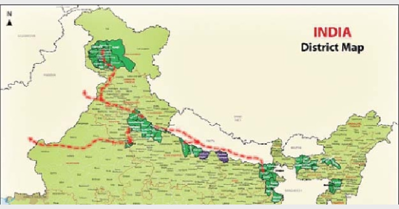
Let us first stare at a map of Northern India, East to West, with regions where Muslims would constitute more than 30% by 2061 colored green. While a population density of 30% Muslims may not be enough to demographically displace the Hindus altogether, as was observed in Kashmir, and is now being observed in several tehsils of hill Jammu, Assam, etc., but 30% Muslim population may provide a critical mass to enable the Pakistani (and possibly Chinese) intelligence to build up a transit corridor. The statistical projections of districts of Western Uttar Pradesh and southern Uttarankhand, West Bengal, Assam and Jammu and Kashmir can be found in [8], [9], [10], and [12] respectively, while those of can be found in Purnea, Santhal Parganas, Bahraich-Gonda and Gurgaon are presented in the current article. We have also marked in purple the districts (Siddharthnagar and Paschim Champaran) in this region that are heavily Hindu majority, but are losing Hindus at high rate (~2% every decade).
|
|
Observe now that the regions colored in green provide a corridor, from the Bangladesh border, right up to Nepal border. This corridor runs from Murshidabad-Maldah, through Dinajpur and Purnea into Nepal. Nepal, being lost to Chinese and Pakistani influence by India, will constitute a long and safe corridor to from the border of Bihar, to the border of Uttar Pradesh. Here it crosses back into India along the Bahraich-Shravasti-Balrampur border, where the Muslim population is high and then has to cross a short strip of Hindu dominated territory in Kheri and Pilibiht, or it can cross farther west in the Shahid Udham Singh Nagar border, before it goes into the Muslim heavy districts of W Uttar Pradesh right up to the Yamuna and the borders of Delhi. From there, there are no Muslim heavy districts, but if the Sikh disaffection increases, there will be an easy passage across Ambala and the districts of Malwa whence it can cross into to Pakistan in Ferozepur district. An idea roughly along similar lines has been utilised by the Pakistani intelligence, in an operation codenamed `Operation Tupac' [14] The other option would be to cross Delhi and move across the Muslim heavy Mewat into the thinly populated regions of North Rajasthan and then into Pakistan, crossing the Bikaner-Jaisalmer border. A third use of this corridor is establish an alternate route into Kashmir from the east and within India itself. This route, too, is contingent on the Sikh disaffection increasing with India. The route crosses into Ambala from Saharanpur, makes its way into Punjabi Malwa and north via the Doab or Majha into Muslim dominated regions of Doda and further north into Kashmir valley.
Thus, the religious demography is changing consistent with the vision of the Mughalistan corridor.
Section B.3: Take Home Message 3 – Strategic blockades
Many of the districts marked green in the maps presented in Section B.2 are strategically located, especially in Bihar-Jharkhand-Bengal and West Assam. We now explain the significance of these.
First note that the districts of Western Assam marked in green can be used as a strategic barrage to cut off Indian access from Northern Bengal into central and upper Assam, with the barrage stretching from the Bangladesh border of Dhubri and Goalpara northwards via Kokrajhar and Chirang to the Bhutan border. A critical mass of hostile populace in this eastern strategic barrage can be utilized for subversive activities that can isolate Northern Bengal from the North East and render the North East totally indefensible during a war.
Second, the districts of Purnea and Santhal Parganas, marked in green may be used as a strategic barrage to disconnect upper and central Ganga valley from the Bengal. The strategic barrage runs from Kishanganj on the Nepal border to Dinajpur, Maldah and Murshidabad on the Bangladesh border, all marked in green. Historically, the Teliagarhi fortress (in today's Muslim dominated area of Santhal Parganas in this region) was the key to Mughal control of Bengal and more than once in history, has proved vital, including in Mughal troubles with the British pp. 36-38, [5]. Similarly, during the Ghadar revolt of 1915, the revolutionaries had planned to blow up the railway bridge near Rajmahal (near the same Teliagarhi fortress) to cut off Bengal from reinforcements in the upper Gangetic valley p. 122, [22]. This is because a major railway line from the upper and central Ganga valley to Bengal, runs in this region, via Katihar (in Muslim dominated old Purnea) and Maldah, before turning south towards Kolkata. This can be seen from the railway map below, where Sahebganj and Katihar have been marked in green consistent with the color code of the maps in Section B.2. The railways running into Assam also go the same route, before turning north into Dinajpur, following the Bangladesh border into Assam. Despite the presence of other railway lines linking the upper Ganga valley with Bengal, this railway line still constitutes the major workhorse line that transports troops and supplies (as it used to during the British times).
Consequently, it may be seen that Sahebganj-Katihar region is vital for our control of the railways into both Bengal and the North East. This is precisely why a hostile critical mass in this region can cut off access to not only Bengal, but also North-East India, including Assam, particularly during any future conflicts in the north east or even disturbances in Bengal or the North East.
Further, the major Hindu pilgrimage of Deoghar (the jyotirlinga of Baidyanath) is located in Santhal Pargana, just west of Muslim dominated Teliagarhi, so a Baidyanath Yatra from Bengal may easily become like the Amarnath yatra – the choice target of Islamists, operating from the safe Muslim hinterlands of Katihar and Sahebganj.
So the demographic shifts are again occurring along regions of enormous strategic importance.
Section B.4: Take Home Message 4: Delhi is Vulnerable
The West Uttar Pradesh and Mewat Muslim belts threaten Delhi from the north-east and the south-west in a pincer, with Mewat about 90 kilometres away and Baghpat about 50 kilometres. To see this, stare at the tehsils marked in green in the map below, they are in the Mewat region, and all have more than 1/3 Muslims right now (except Lachmangarh). Next, stare at the districts marked in purple, they are in Western Uttar Pradesh and all of these will be Muslim majority or close in 50 years. The Hindu percentage in both sets of marked regions are decreasing rapidly. Note their proximity to the large cities, commercial and political hubs, Alwar, Gurgaon, Bharatpur, Faridabad and Delhi. We provide the religious demography statistics of Tehsils 1-9 (of Mewat) below, and have provided the statistics for those of Western Uttar Pradesh (Meerut, Baghpat Saharanpur and Muzaffarnagar) in [8].
The Tehsils 1-9 (of Mewat are in the South and South-West of Delhi, and the districts of Meerut, Baghpat Saharanpur and Muzaffarnagar are just north of Delhi. So Delhi will practically be surrounded on all sides by heavy Muslim regions in the next fifty years. The recent Muzaffarnagar riots just north of Delhi, and the rising crime graph in Mewat [20] show just how vulnerable the city already is.
We now focus on the religious demography of Tehsils, 1-9 in the entire Mewat region which spans 4 districts – Mewat, parts of Palwal, parts of Alwar and parts of Bharatpur districts. The historical Mewat region used to consist of the Mewat district, Hathin tehsil of Palwal, Tijara, Kishangarh Bas, Ramgarh and Lachhmangar, in Alwar, and Nagar, Kaman and Pahari tehsils of Bharatpur district. This North eastern corner of the Aravallis is the traditional haunt of the Meo Muslims and it has spanned the border of Rajasthan and Haryana along the Aravallis. Almost all of the Muslim population of the Gurgaon (aggregated) district can be found in the Mewat region. The current Mewat district has more than 70% Muslims and the Muslims in the region have been growing between 40 and 60% every decade, despite considerable emigration. The Total Fertility Rate of Mewat district (which is predominantly Muslim) was 4.9 [3]. The growth of the Muslims in the four tehsils of Taoru, Nuh, Ferozepur Jhirka and Punahana of Mewat district, the Hathin tehsil of Palwal and parts of Alwar and Bharatpur districts is exceptionally high as we show in the table below. For the sake of comparison, we have included the Muslim and Hindu growth rates in all the tehsils of Mewat region:
Tehsil | District | Hindus in 2001 | Hindus in 2011 | Hindu Growth 2001-2011 | Muslim Growth 2001-2011 |
Taoru | Mewat | 50.82 | 42.2 | 9.76 | 55.19 |
Nuh | Mewat | 28.82 | 23.21 | 8.19 | 45.69 |
Ferozepur-Jhirka | Mewat | 17.44 | 14.4 | 19.36 | 44.39 |
Punahana | Mewat | 14.76 | 12.48 | 19.35 | 44.71 |
Hathin | Palwal | 45.62 | 40.59 | 17.2 | 43.2 |
Tijara | Alwar | 64.58 | 62.02 | 35.91 | 51.51 |
Kishangarh-Bas | Alwar | 70.37 | 66.37 | 17.54 | 39.58 |
Ramgarh | Alwar | 65.81 | 61.73 | 18.79 | 42.02 |
Lachmangarh | Alwar | 78.11 | 75.02 | 14.81 | 35.84 |
Pahari | Bharatpur | 31.62 | 26.96 | 14.99 | 43.56 |
Kaman | Bharatpur | 59.94 | 54.93 | 18.51 | 45.24 |
Nagar | Bharatpur | 68.41 | 64.08 | 15.82 | 40.8 |
Table 4: The percentages of the actual populations of the Hindus and Muslims are shown in columns 3 and 4 respectively, and the growth rates of the Hindus and Muslims in percentage terms are shown in columns 5 and 6 respectively are shown in the table
From the above growth rate disparity, one may easily see that the Meo Muslim community is rapidly growing and so fast that Hindus are being turned into the minority in so many tehsils, not only in the present Mewat district, but also in many neighboring districts. The Mewat region is therefore demographically expanding in all directions. The Hindu percentage fell 2.1% in Bharatpur district, and 2.28% in Alwar district between 2001 and 2011 – an unprecedented fall for a district where Hindus are >80%. The same trend is visible in the southernmost tehsil of Gurgaon district, Sohna (lost 2%), the western most tehsil of Mathura district, Chhata (lost 2%). Further, perhaps due to spread of Muslims from Muzaffarnagar, Panipat district in Haryana lost 1.5% Hindus. Sohna, Panipat and Chhata are overwhelmingly Hindu at the moment, but yet, are losing Hindus at a surprisingly high rate; the rate of loss is particularly surprising given how high the Hindu percentage is in these. The trend is set to accelerate in the coming years, with falling Hindu fertility rate and a surprisingly high Meo Muslim fertility rate..
With the sharply falling Hindu percentages, not only in Muslim heavy Meerut, Muzaffarnagar, Baghpat and Mewat, but also in adjoining tehsils of Palwal, Gurgaon, Panipat and Mathura, Delhi and the commercial hubs of Guegaon and Faridabad are not only caught in a pincer from the north east and south west, but they are being strategically encircled. The vulnerability of these constitutes a serious physical threat to the poor there (the rich are rarely affected by riots), and an equally potent threat for regions in the periphery of India. The Indian state has a long tradition of creating a hierarchy among regions depending on their political and commercial significance. This was seen in how Hindu majority districts (eg, Khulna) were traded off during partition to retain Muslim majority ones (eg, Murshidabad) of greater perceived commercial value (To keep Kolkata port open, it was necessary that India should control the headwaters of the Bhagirathi, near Murshidabad; Hindu majority Khulna, in contrast, was a major rice growing area, but little else) pp. 45-46, [25]; in how Assam and the North East were left to the mercy of the Chinese army in 1962 (Nehru’s famous speech bade farewell to the people of Assam, telling them to fight on as they could while he and his people fled, p. 107, [26]) ; in how almost the entire North East was allowed to be converted to Christianity without a semblance of resistance. Thus the vulnerability of the political and commercial hubs may well serve as a bargaining chip in the hands of the subversive elements to compel Delhi to concede their other demands, including compromise of Hindu interests in peripheral areas of perceived lower commercial import like what remains of North East, Assam, West Bengal, Kerala, Andhra Pradesh, Tamil Nadu, Odisha, Punjab, Jammu and Ladakh.
Section B.5: Take Home Message 5: Political indifference
It has been proposed in RW circles that the Congress and other secular parties patronise the Islamists and the evangelists and other proselytisers, but the BJP opposes them. However, Jharkhand stands as a strong counter-example to that theory. Of the 11 years that passed between the formation of Jharkhand and the 2011 census, BJP had been in power for over 7 years. The Christian population of Santhal Parganas increased by 3.5 times between 1991 and 2011, and nearly doubled between 2001 and 2011. However, the BJP has taken no steps to check the rapid growth of Christianity (despite its avowed opposition to proselytisation). Since 2014, the BJP has been in power again in Jharkhand, and has nevertheless, taken no steps to check the growth of Christians. A law against fraudulent conversions has been in vogue in Gujarat since early 2000s, but no such move is proposed in Jharkhand. Enacting such a law would inevitably lead to a significant backlash due to the wide reach of the missionary lobbies and their connections to human rights groups, global commercial interests, journalists and politicians in India, and substantial political capital would be necessary to counter the backlash. It is interesting that the BJP would expend its political capital for Gujarat, but won't risk the same for Jharkhand. The reason for the BJP not risking political capital in taking on the church is for people to speculate, but facts of the matter are as follows. In 2006, proposal for anti-conversion law had been proposed by RSS-backed BJP, but the latter chickened out when JDU threatened to withdraw support and topple the government. Church websites celebrated this news openly [4]. Although VHP has started raising demands for the anti-conversion law again 2013 onward, yet the so-called Hindu nationalist BJP hasn’t done anything on that front since regaining power in 2014. In contrast, in the 3 decades from 1961 and 1991, the Christian population just grew to slightly more than double its population (and at nearly the same rate as the Hindu tribal population).
Section C: Statistical Details of Projections for Religious Demography
For all the districts that have been named, we have computed the growth rates across different communities of significance using the constant growth, the polynomial and the logistic models. We have analysed the results of all the three techniques separately.
Section C.1: Constant Growth Model
In the constant growth model, we have assumed that the average growth over the last 2 decades for the different communities will hold in future and have predicted the populations based on those numbers. The populations of the various communities in the various districts have been shown above.
In the above graphs, it can be seen that Hindus fall below the 50% mark in both Purnea and Santhal Parganas. The collapse of Hindus in Santhal Paraganas is catastrophic. From 90% in 1951, Hindus are set to fall to 42% in 2061, a collapse of nearly 50 percentage points in 100 years. Both Christians and Muslims are growing by leaps and bounds in the district. Gurgaon and Bahraich-Gonda are also seeing the Muslim population percentage essentially doubling in 100 years.
Section C.2: Polynomial Model
In the polynomial model, we have fitted a cubic polynomial, minimising the square error for the different communities. The cubic model can more accurately model the rapid rises and fall in the changes.
In the polynomial model, only the Purnea district will be Hindu minority by 2061. In the case of the Bahraich-Gonda and Purnea, the constant growth model and the polynomial model agree more or less. In the case of the Santhal Parganas, the polynomial model puts the Hindu population much higher (nearly 11%) higher than the constant growth model. This, we believe, is a more accurate representation since once all the tribals have been converted (it is tribals who are converting, for the most part) in the region, the rate of growth of Christian population will subside. In the case of Gurgaon, since the growth is inorganic in the case of the Hindus (most growth is occurring via immigration than via natural growth), the polynomial model overestimates the Hindu population.
Section C.3: Logistic Model
In this logistic model, we try to fit a logistic curve to the data points, minimising the square error in the process. We do not believe that this technique is a good fit for the region that is showing rapid changes in populations like Gurgaon or Santhal Parganas (See reasons given in [12]) . However, for the sake of completeness, we have included this technique in our examination too. The logistic model may be considered a lower bound on the changes possible.
In the logistic model, we can see that Purnea becomes Muslim majority in 2051, but other regions have a Hindu population ranging from 60.1% in Santhal Parganas to 70.7% in Gurgaon. The population of Santhal Parganas shows a massive drop in this model too. Gurgaon also shows a sharp drop, with the Muslim population expanding from 16% in 1951 to 29% in 2061 and Bahraich shows a Muslim population rise from 20% in 1951 to 35% in 2061.
Conclusions
We have shown the number of pockets in the Hindi heartland where the Hindus are falling sharply and may well become minorities either in entire districts like old Purnea and old Santhal Parganas or local minorities in Balrampur, Mewat, etc. We have also shown the serious security implications and the possible formation of a Mughalistan corridor. Finally, we have shown the possible isolation of parts of the country from others.
References
[1] Sankar Ghosh, “Jawaharlal Nehru: A Biography'',
[2] LSS O'Malley, “Purnea District Gazetteer'', 1908
[3] CZ Guilmoto and I. Rajan, “Fertility at District Levels in India: Lessons from the 2011 census'', http://www.ceped.org/IMG/pdf/ceped_wp30.pdf
[4] “Church Happy as Conversion Bill Threatens State Government'', http://www.ucanews.com/story-archive/?post_name=/2006/08/30/church-happy-as-conversion-bill-threatens-jharkhand-states-coalition-government&post_id=27867
[5] National Geographic Journal of India 16.112
[6] K. K. Sinha, Excavation at sravasti, 1967
[7] Minhaj -US -Siraj, “Tabakat i nasiri, Trans. History of India as told by its own historians volume 2'')
[8] Shanmukh, Dikgaj and Saswati Sarkar, “Western Uttar Pradesh and Southern Uttarakhand: Muslim Majority by 2061?'' http://www.dailyo.in/politics/population-muslims-muzaffarnagar-uttarakhand-shamli-western-uttar-pradesh-hindus-sikh-demography/story/1/10631.html
[9] Shanmukh, Dikgaj and Saswati Sarkar, “A Demographic Warning for West Bengal'', https://www.myind.net/demographic-warning-west-bengal
[10] Shanmukh, Saswati Sarkar, Dikgaj and Aparna, “Will Assam be Muslim Majority in the next 40 years?'' http://indiafacts.org/will-assam-muslim-majority-next-40-years/
[11] Shanmukh, Saswati Sarkar, Dikgaj, and Aparna, “Kerala and South Tamil Nadu – A Case of Hindu Fade out'' http://indiafacts.org/kerala-south-tamil-nadu-case-hindu-fade/
[12] Shanmukh, Vikram, Aparna, Saswati Sarkar, and Dikgaj, “The Demographic expansion of Kashmir and the shrinking of Jammu and Ladakh'' https://www.myind.net/demographic-expansion-kashmir-and-shrinking-jammu-and-ladakh#.V3UOVSF0xwc.twitter
[13] LSL O'Malley, “District Gazetteer of Santal Parganas'', 1910
[14] Sean Winchell, “Pakistan's ISI: The Invisible Government'', International Journal of Intelligence and CounterIntelligence, Vol. 16(3), http://www.tandfonline.com/doi/abs/10.1080/713830449
[15] HR Neville, “District Gazetteer of Gonda'', 1905
[16] HR Neville, “District Gazetteer of Bahraich'', 1903
[17] Shail Mayaram, “Perspectives on Violence and Othering in India''
[18] Gurgaon District Gazetteer, 1883.
[19] NB Khare, “My Autobiography, or my Political Memoirs''
[20] Gangs of Mewat http://www.hindustantimes.com/india/in-mewat-govt-s-indifference-and-neglect-a-bigger-reality-than-crime/story-FaXR9hW7KNlqvSRpn0iAUL.html
[21] Partha Ghosh, “Migrants, Refugees and the Stateless''
[22] Lord Rowlatt Committee, “Seditions Committee Report''
[23] Kazi Fahmida Farzana, “The Neglected Stateless Bihari community in Bangladesh : victims of political and diplomatic onslaught'' Journal of Humanities and Social Sciences, Vol 2,Issue 1, 2008
[24] Encyclopaedia Britannica “Nehru-Liaqat Pact or Delhi Pact'', 1950
[25] Joya Chatterjee, “The Spoils of Partition''
[26] Braja Bihari Kumara, “Illegal Migration from Bangladesh''
(This article has been co-authored by Shanmukh, Aparna, Vikram, Arihant, Saswati Sarkar, and Dikgaj)