
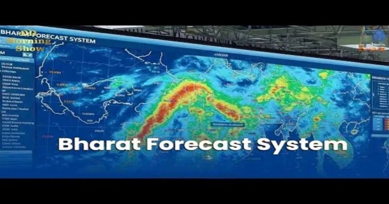
India has opened a new page in the field of weather forecasting with the unveiling of the Bharat Forecast System, an indigenous high resolution global weather model created through the joint initiative of IITM Pune, IMD and NCMRWF-Noida. The Ministry of Earth Sciences (MoES) has launched the Bharat Forecast System on 26 May 2025 officially for operational-level weather forecasting in the country. It has been designed by Indian researchers marking a major breakthrough in the country’s scientific, strategic and economic horizon.
Revolution in the field of Forecasting
Bharat Forecast System is the Triangular Cubic Octahedral (TCo) dynamical grid, a technology that allows the model to function at a 6 km horizontal resolution. This is a major leap from its predecessor model the GFS T1534, which worked at approximately 12 km and is much sharper than the 9 to 14 km resolution of most global operational models. This resolution means that highly localized weather data can be delivered by BharatFS, a feat which was previously out of reach for all the panchayats and villages. Farming and livelihoods depend heavily on micro-level weather conditions in a country like India and hence this advancement holds a key to future.
The system operates over India’s advanced supercomputing facilities Arka (IITM-Pune) and Arunika (NCMRWF-Noida). These machines have cut down the forecast runtime drastically, from 12 hours to just 3-6 hours. Thus, making it possible to use the model for real-time weather prediction. BharatFS is now the only global weather prediction model in the world operating at such high resolution in real time due to its high accuracy and speed, this places India ahead of leading nations in meteorological science.
In the research phase the results of BharatFS have been quite encouraging. Across the overall monsoon area, the model has been found to be 30% more accurate in forecasting extreme rainfall from the previous operational model. With more frequent extreme weather events from the impacts of global change, this precision is not only a scientific development but also useful in disaster preparation and management tool.
Direct Benefits to People and Agriculture
The in-practice effect of BharatFS is wide-reaching. With the capability to produce forecasts at intervals of every 6 km, farmers will be able to sow, irrigate and reap with greater certainty. Water authorities can manage reservoirs better, reducing flood risks and optimizing water storage. Faster and targeted disaster response teams make communities more resilient to floods, cyclones and heatwaves. In a nation where farming sustains nearly half of the nation, a localized forecasting could protect livelihoods and bolster crop yields.
Aatmanirbhar Bharat Initiative in Forecasting Technology
The system has been developed from a cumulative effort of the scientists of India at centers like IITM-Pune in association with the NCMRWF-Noida and the India Meteorological Department (IMD). The system functions through Ministry of Earth Sciences (MoES) supercomputing centers without foreign support hence marking the power of Indian science.
This achievement reflects the spirit of Make in India and Aatmanirbhar Bharat, proving that India can build world-class systems to its unique geographical challenges, including the Himalayas and the Western Ghats.
The establishment of BharatFS enhances India’s regional leadership beyond its borders. Through advanced forecasting, India is capable of supporting neighbouring nations with dependable meteorological services that reinforce regional leadership as well as self-sufficiency. It will support India with its long-term strategic and economic missions.
Why this is important for India
India is one of the world’s most climatically vulnerable nations. The unpredictability of monsoon rains, floods and cyclones threaten millions of people annually. BharatFS will tackle this challenge head-on by enhancing disaster preparedness, saving lives and assets. Agriculture relies greatly on accurate forecasts of rainfall and bolstering the economy through the minimisation of crop loss, enhancements in the management of waters and a reduction of disaster relief expenses. By targeting panchayat-level forecasts, this model brings science directly to the grassroots level so that the remote location communities get benefit.
With 30 per cent greater accuracy in predicting extreme rainfall and substantial improvement in monsoon forecasts, BharatFS is already outperforming older systems. Its real-time capability and high resolutions can capture small-scale weather phenomena that larger grid models often miss. This translates to more reliable forecasts, especially in diverse terrains like Western Ghats and Himalayas. Thus, placing India ahead of most developed countries in the category of meteorology and it marks the shift of the nation from a recipient of weather data to that of a world leader in the weather sciences and climate.
The Bharat Forecast System is more than a scientific achievement, it is a declaration of India expanding capacity in high-technology and climate robustness. With indigenous design, world-leading computing capacity and high-quality resolution, BharatFS enhances India leadership in the world of forecasting weather. It is a technology not only for forecasting the climate, but also for farmers, citizens and institutes. Thus, ensuring that science serves the people directly. At a time when climate change is changing weather patterns, BharatFS gives India sharper, faster and stronger insights into the future of weather.


Comments