Radhakrishna Rao
On April 28, 2016 Bharat completes its landmark mission for a home-grown navigational system with the successful launch of IRNSS-1G
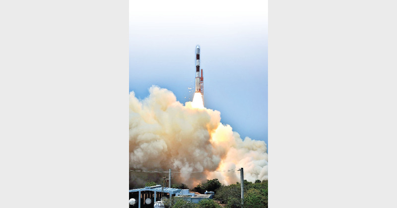
The flawless and text book perfect launch of IRNSS-1G, the last and seventh satellite of the Indian Regional Navigation Satellite System (IRNSS), on April 28, from the Satish Dhawan Space Centre (SDSC), Sriharikota has paved the way for the Indian Space Research Organisation (ISRO) to operationalise a full-fledged, national satellite navigation system that could be used for a range of civilian and military uses. By all means, lRNSS is a strategic national asset that the country can be proud of to possess. IRNSS-1G satellite was orbited by means of an augmented XL version of the trusted, four stage Indian space workhorse, PSLV (Polar Satellite Launch Vehicle) in around twenty minutes after its majestic take off from the first launch pad of SDSC. The satellite, designed for a mission life of twelve years, was placed into a sub geosynchronous transfer orbit by the thirty fourth consecutively successful PSLV mission. As it is, PSLV-XL was also deployed for launching India’s maiden lunar probe, Chandrayaan-1 in 2008 and also the first interplanetary probe, Mangalyaan mission to Mars in 2013. As it is, some of the advantageous features of IRNSS include highly precise position, velocity and time information data with a good accuracy for a single frequency user with the help of ionospheric correction and all weather round the clock operation. As pointed out by sources in ISRO, the home-grown IRNSS, in distinct contrast to the commercial navigation platforms, would provide signal coverage even in the remote areas of the country with a high degree of precision.
In an address to the nation in the aftermath of IRNSS-1G launch, Prime Minister Narendra Modi named the system NAVIC (Navigation with Indian Constellation) and stressed the point that it will make the country totally self reliant by ending its dependence on foreign support platforms for vital navigation services. “The new technology will benefit our people, our fishermen and sailors,” said Modi. Not surprisingly, Modi pointed out that IRNSS stands out as a proud example of Make in India and Made for India initiatives. While appreciating the innovative efforts of ISRO in bequeathing this gift to the nation”, Modi noted that the potentials of NAVIC could be harnessed to benefit the countries of the SAARC (South Asia Association for Regional Co-operation) region. Thanks to the initiative of Modi, a satellite meant to cover the countries in the SAARC region with a range services would be launched by the end of this year. Of course Pakistan had decided to opt out of the SAARC satellite project. This satellite system being built by ISRO has been described as Bharat’s gift to its neighbours.
With the completion of the IRNSS constellation, India has notched up the distinction of being the fifth country in the world to design, build and operate a sophisticated satellite navigation system. The importance of IRNSS lies in the fact that it would free the country from its dependence on American GPS system. In fact, during 1999 Kargil war with Pakistan, USA had denied Bharat the access to the restricted services of GPS which is under the control of US military. In a way, the US refusal proved to be a blessing in disguise in that it nudged India to develop its own satellite navigation system in the form of IRNSS. IRNSS is similar to the other global satellite navigation systems including GPS of USA, Glonass of Russia, Galileo of Europe and BeiDou of China. For the Bharatiya defence forces, the importance of a fully home-grown navigation satellite system that can be harnessed without any hindrance need not be overemphasised. According to ISRO, the total cost of all the seven satellites of IRNSS constellation was Rs 1,420 crore.
While the navigation payload is designed to transmit navigation service signals to the users in L5 and S bands, the ranging payload made up of a C-band transponder would facilitate the accurate determination of the range of the satellite. Significantly, a highly accurate Rubidium atomic clock, forming a part of this satellite, is a vital component that would make available time and location signals to users on land, sea and air. In addition, IRNSS satellites carry a Corner Cube Retro Reflector for laser ranging.
The IRNSS spacecraft constellation is designed to provide accurate position information service to users in Bharat as well as the region extending upto 1,500 km from its boundary. Further, the IRNSS constellation is equipped to provide a Standard Positioning Service (SPS) and Restricted Service (RS) and is expected to provide a position accuracy of better than 20-m in the primary service area (Bharat). Some of the civilian applications for which IRNSS could be harnessed include terrestrial, aerial and marine navigation, disaster management, search and rescue operations, vehicle tracking and fleet management, supporting mobile telephone services, mapping and geodetic data capture, terrestrial navigation aid for hikers and travellers as well as visual and voice navigation for drivers.
For the Bharatiya defence forces, the availability of a home-grown, exclusive navigation satellite system would be a big morale booster. For it was the non availability of a satellite based navigation service that had hindered Bharatiya army’s intelligence missions before and during the 1999 short lived Kargil war with Pakistan. However, with IRNSS in place, Bharatiya defence forces will not have problem locating targets, navigating the movement of troops and supplies and launching precision weapons with a high degree of accuracy at enemy targets.
An independent satellite navigation capability is also critical for the Bharatiya defence establishments’ plan to refine and enhance the network centric warfare capabilities of the defence forces. Similarly, a well endowed satellite navigation capability is also critical for the proposed tri service Bharatiya aerospace command, the formation of which is awaiting clearance from the Bharatiya Government. For the defence forces, in the thick of operations in the remote and difficult to access war zones, a GPS system similar to IRNSS enables locating objects and landmass in the darkness and paves the way for coordinating the troop movements in a hitherto unfamiliar area in addition to facilitating reconnaissance as well as search and rescue operations.
All said and done, there is no denying the point that an independent satellite positioning system like IRNSS cannot but be a valuable, strategic asset for the country especially during the times of crisis when the possibility of international navigation satellite operators denying access for their service cannot be discounted. Clearly and apparently, continuous and uninterrupted access to exclusive, dedicated navigation satellite systems, have now become indispensable for the combat aircraft, naval warships and ground based troops to acquire a head start in the battle zone and ultimately stay at the winning edge of the war. For Bharat, which is all poised to position itself as a technological and military super power in the none too distant a future, the need to own and operate an independent navigation satellite system has become the paramount need of the hour.
However, at the end of the day, the potentials of IRNSS can be harnessed only through the availability of navigation receivers to be manufactured on a large scale at an affordable price. One of the suggestions put forth to encourage the popularisation of navigation devices designed to work in tandem with IRNSS is the mandatory use of the services of NAVIC by the all wings, agencies and departments of the central and state governments. There is no denying the fact that in the days ahead IRNSS could very well occupy a pivotal position in the developmental saga of the country.
(The writer is a freelance columnist who writes on Science, Tech and Defence related issues )