Ashok B Sharma
 Indian diplomacy on China has failed squarely as it has not been able to assert the Johnson Line in the northern sector and the McMohan Line in the eastern sector, drawn by the colonial rulers as India’s boundary line. This is despite the fact that India’s official map has recognised these lines since Independence.
The Chinese have forcibly occupied Indian territory in the northern and eastern sectors. In total, China occupies more than 20,000 sq km of Gilgit-Baltistan (including 5,800 sq km ceded to it by Pakistan who had occupied it from India), apart from a large chunk in Ladakh. It is ironic that while India constantly negotiates with Pakistan over its occupation of parts of Jammu & Kashmir, it has not done so with China.
The recent Border Development Cooperation Agreement (BDCA) signed during Prime Minister Manmohan Singh’s visit to Beijing is the last nail in the coffin of Indian diplomacy. The agreement blatantly admits there is no common understanding on the Line of Actual Control (LAC). Does this leave any possibility of border cooperation with China?
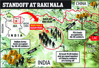
The agreement says that the two sides shall carry out border cooperation on the basis of their respective laws and bilateral agreements. Will China honour this agreement given that it has violated similar agreements on many previous occasions? Further, the BDCA says that the two sides agree on not trailing patrols of the other in areas where there is no common understanding of the LAC. But the Chinese continue to walk into Indian territory blatantly as they did recently in Chumar, and Depsang in Daulat Beg Oldi sector near Aksai Chin.
India has stopped patrolling in some areas along the LAC. Lack of infrastructure on the Indian side makes Chinese infiltration easier. Moreover, India is forbidden to follow the Chinese patrol. After each Chinese intrusion, our leaders get into denial and cover up citing “differing perceptions about the LAC”.
The fact is that India has not yet understood the Chinese ploy of Sun Tzu – the supreme art of war where enemy is subdued without fighting — which China has been playing since 1962. The Chief of Air Staff NAK Browne had rightly said that had Indian Air Force (IAF) been directly involved in the 1962 war, the Chinese would have been pushed back — just as the IAF had pushed back the Pakistanis from the Kargil sector.
In response to the Sun Tzu ploy, India repeats that the border is “undefined”, even though the country’s official map has clearly defined borders.
In 1865, the British drew India’s northern boundary with Tibet, sensing the likely expansionist plans of Russia and the Middle kingdom. It extended beyond the Kuen-Lun (Kunlun) mountains and included the Aksai Chin desert and the 18,000 feet high Karakoram pass in the north. Drawn by WH Johnson of the Survey of India, this was called the Johnson Line.
To seek Chinese agreement to this line, the then Viceroy Lord Curzon in 1899 tried to exclude much of the Aksai Chin and proposed the MacCartney-Macdonal Line, but the Chinese refused. Interestingly, this line largely coincides with the LAC and the Chinese claim line. However, given Aksai Chin’s strategic importance and the aggressive designs of the pro-Soviet Sinkiang government, the British reverted to the Johnson Line in 1940-41.
As Tibet was then independent of China, the Chinese consent was not necessary and the British declared Tibet as a buffer state, making Johnson Line the northern boundary between India and Tibet.
In the North-East, the British had taken control over the hills in 1886 when an expedition had gone up to the far end of Arunachal Pradesh. But in the western end of the sector, east of Bhutan, the Tibet-administered Tawang tract was Left as open country.
The Chinese began asserting their rights over Tibet by mid-1910 in response to which, Viceroy Hardinge ordered a “sound strategical boundary” in 1911. In September 1911, the British decided the Outer Line, including the Tawang tract, as the boundary with Tibet-cum-China.
The British called a conference in Simla in 1913-14 on the issue which the Tibetans and the Chinese attended. This gave birth to the McMohan Line — after the leader of the British delegation, Henry McMohan — which extended to the edge of the Tibetan plateau. The Survey of India for the first time showed McMahon Line as the official boundary. Though Tibet did not accept the “annexation” of the Tawang tract, it accepted the rest of McMohan Line. The Chinese, however, repudiated the Shimla Convention and the McMohan Line.
It is unfortunate that since Independence, India has failed to assert claim on Johnson and McMahon Lines.
Chinese control of Aksai Chin and Shaksgam was a strategic move in exchange for nuclear assistance to Pakistan. On March 2, 1963, Pakistan allowed China to occupy Shaksgam, Raskam, Shimshal and Aghil valleys of Gilgit-Baltistan.
China has already built feeder roads through Shaksgam linking Gilgit with Hotan, and a road along south-eastern Turkmenistan connects Gilgit with Aksai Chin. It has also connected north-western Tibet to Pakistan’s Gwadar Port and ports in Iran. China is now constructing a 200 km long tunnel in Gilgit-Baltistan to connect Kashgar and Gwadar by rail. Pakistan, in return, will set-up Chinese industrial zones along the Karakoram Highway and lay optic fibres across the Karakoram Mountains.
China has given priority to roads between Tibet and Turkmenistan since its occupation of Tibet in 1951. According to the official report of the 1962 Chinese aggression, “The preliminary survey work on the Tibet-Sinkiang road having been completed by the mid-1950s, China started constructing a motorable road in 1955. The highway ran over 160 km across the Aksai Chin region of north-east Ladakh. It was completed in the second half of 1957.”
India’s first Prime Minister Jawaharlal Nehru remained delusional and couldn’t see through the Chinese rhetoric of Hindi-Chini Bhai-Bhai, or else Tibet could have been saved. On China’s objection, Nehru also closed the Indian Consulate in Kashgar, though India had been trading with Central Asia for millennia.
China is now encircling India by its String of Pearls in the Indian Ocean, by its presence in Myanmar, Sri Lanka and Pakistan. Nepal, too, often dances to Chinese tunes. In the east, China claims Doklam Plateau in Bhutan and intends to cut off the Chicken Neck Corridor connecting mainland India with the North-East.
Contrarily, India has not taken any steps to circle China in the East and South China Seas despite offers from the Philippines and Vietnam. India’s presence there is limited to a few oil exploration blocks some of which China has already scuttled.
It is time India took on China for its territorial integrity. An article in a pro- government Chinese newspaper, Wenweipo, has outlined China’s six war strategies in the next 50 years to avenge the humiliation of Imperial China by the British in the Opium Wars (1840-42). The Chinese government has not yet contradicted the article.
The article states that of the six wars, the third would be for “re-conquest” of Southern Tibet (Arunachal Pradesh) in 2035-40. It writes: “China has long been the imaginary enemy of India. The military objective of India is to surpass China. India aims to achieve this by self-development and importing advanced military technologies and weapons… The best strategy for China is to incite the disintegration of India.”
“Of course, such plan may fail. But China should at least try its best to incite Assam and the once-conquered Sikkim to gain Independence…” the article adds.
The article also suggests export of “advanced weapons to Pakistan, helping it to conquer Southern Kashmir region in 2035… While India and Pakistan are busy fighting each other, China should take a blitz to conquer Southern Tibet, at the time occupied by India.”
For India, the writing on the wall is clear.