
With the successful launch of the fifth in the seven spacecraft constellation, Bharat is all set to launch a sophisticated indigenous satellite navigation system for both civilian and military uses
In a significant step forward for enhancing Bharat’s satellite based navigation capability, Indian Space Research Organisation (ISRO) on January 20 successfully launched IRNSS-1E navigation satellite, the fifth in the seven spacecraft IRNSS (Indian Regional Navigation Satellite System) constellation. The four satellites in IRNSS configuration are already in service and the entire IRNSS constellation is planned to be completed during the course of this year with the launch of two more satellites. According to ISRO, the concept of IRNSS system proved a success by the signals received from the first four orbiting IRNSS navigation satellites. The IRNSS constellation has also as part of its system two ground spare satellites.
|
Bharat to build satellite tracking station in Vietnam Bharat will set up a satellite tracking and imaging centre in southern Vietnam that will give Hanoi access to pictures from Bharateeya earth observation satellites that cover the region, including China and the South China Sea, Bharateeya officials have reportedly confirmed. |
Bharat is now the sixth country in the world to design, build and operate a sophisticated satellite navigation system like IRNSS which can be harnessed for a range of civilian and military uses. The strategic significance of IRNSS constellation lies in the fact that it has freed the country from its dependence on American GPS system. In fact, Bharat did encounter difficulties while accessing the restricted services of GPS. IRNSS is similar to the other global satellite navigation systems including GPS of USA, Glonass of Russia, Galileo of Europe and Beidou of China.
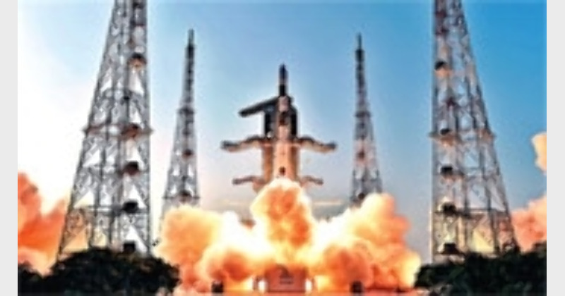
Significantly, the precise, text book perfect launch of IRNSS-1E was pulled off by an augmented version of the four stage, Bharateeya space workhorse, PSLV (Polar Satellite Launch Vehicle) designated PSLV-XL. This is for the eleventh time that an XL version of PSLV known for its excellent track record of launching Bharateeya satellites as well as spacecraft of international customers on commercial terms has been deployed by ISRO. With a lift of weight of 320-tonne, the PSLV-XL delivered IRNSS-1E into its precise, pre determined orbit in around twenty minutes of its majestic lift off from the second launch pad of Satish Dhawan Space Centre (SDSC) in Sriharikota Island on Bharat’s eastern coast.
With a lift off mass of 1425kg, IRNSS-1E, like its predecessors, features navigation and ranging payload. While the navigation payload is designed to transmit navigation service signals to the users, the ranging payload made up of a C-band transponder would help determine the precise range of the satellite. Significantly, a highly accurate Rubidium atomic clock forms a part of this satellite. In addition, IRNSS-1E also carries Corner Cube Retro Reflector for laser ranging. IRNSS can be used for both civilian and military applications. The civilian applications of IRNSS include terrestrial, aerial and marine navigation, disaster management, vehicle tracking and fleet management, mobile phone integration, mapping and geodetic data capture. Not long back, the Bharateeya Prime Minister Narendra Modi, whose space diplomacy has won laurels from one and all, had suggested the need for Bharat to make available the services of IRNSS to the neighbouring countries in the South Asia region.
For the Bharateeya defence forces, the availability of a home grown navigation satellite system would be a big morale booster. For it was the non availability of a satellite based navigation service that had hindered Bharateeya army’s intelligence missions before and during the 1999 short lived Kargil war with Pakistan. However, with IRNSS in place, Bharateeya defence forces will not have problem locating targets, navigating the movement of troops and supplies and launching precision weapons with a high degree of accuracy at enemy targets. In fact, USA was able to accomplish its military missions in Afghanistan and Iraq with a high degree of success mainly due to the availability of satellites navigation services.
An independent satellite navigation capability is also critical for the Bharateeya defence establishments’ plan to refine and enhance the net- work centric warfare capabilities of the Bharateeya defence forces. Similarly, a large satellite navigation capability is also crucial for the proposed tri service Bharateeya aerospace command the formation of which is awaiting clearance from the Bharateeya Government. For the defence forces, in the thick of operations in the remote and difficult to access war zones, a GPS system similar to IRNSS enables locating objects and landmass in the darkness and paves the way for coordinating the troop movements in a hitherto unfamiliar area in addition to facilitating reconnaissance as well as search and rescue operations.
The IRNSS spacecraft constellation is designed to provide accurate position information service to users in Bharat as well as the region extending upto 1500 km from its boundary. Further, the IRNSS constellation is equipped to provide a Standard Positioning Service (SPS) and Restricted Service (RS) and is expected to provide a position accuracy of better than 20-m in the primary service area. IRNSS series of satellites are built for a power handling capacity of 1660-watts and are designed for an active, mission life of around ten years. All the seven satellites in the constellation have identical configuration and will have continuous radio visibility with the Bharateeya control station to help transmit codes and data in S and L5 bands.
On its part, ISRO has made it clear that depending upon the developments in future, the seven satellite configuration of IRNSS will be augmented with more spacecraft that would ultimately help expand the scope of IRNSS constellation. All said and done, there is no denying the point that an independent satellite positioning system like IRNSS cannot but be a valuable, strategic asset for the country especially during the times of crisis when the possibility of international navigation satellite operators denying access for their service cannot be discounted. Clearly and apparently, continuous and uninterrupted access to exclusive, dedicated navigation satellite systems, have now become indispensable for the combat aircraft, naval warships and ground based troops to acquire a head start in the battle zone and ultimately stay at the winning edge of the war. For Bharat, which is all poised to position itself as a technological and military super power in the not too distant a future, the need to own and operate an independent navigation satellite system has become the paramount need of the hour. Radhakrishna Rao


Comments